Showing posts with label West Desert. Show all posts

05 July 2024

Maps by W.D. Rishel


Maps are fun! This 1917 map from the Salt Lake Tribune shows SLC as the Crossroads of the West, although the specific verbiage used in the description was “automobile touring center of the west.” Where the tourist must top for supplies and information… whether traveling east, west, north, or south.

This 1917 map was made by W. D. Rishel, manager of the Utah Automobile Association, and shows several travel routes. You will note that many of these routes eventually evolved into our Interstate Highway system while others (notably the Lincoln Highway through Fish Springs) were abandoned.

• Lincoln Highway
• Midland Trail
• Pike’s Peak Route
• Arrowhead Trail
• Evergreen Highway
• Yellowstone Highway

28 May 2023


A day trip through Tooele County to see the spring wildflowers in Utah's West Desert.

07 October 2022

Places that SHOULD be haunted based on their histories

I’m not sure how ghosts work, but there are plenty of places around SLC that should be haunted based on their history. Here are a few areas that may qualify as Spooky Salt Lake City. 

1. Sugar House Park, the site of the old Utah State Prison, was the scene of several executions and the site of a prison cemetery.


2. The Palladio Apartments were literally built on a burial ground. This block, just east of Pioneer Park, was the first cemetery of the Mormon Pioneers, which was also dug into an Indigenous burial area. All the Mormon settler’s human remains were removed in the 1980s and reburied at This is the Place State Park. But funding and time did not allow the same courtesy for the Native American burials; partial human remains were recovered from 3 individuals, and more were [are?] likely present.
 
3. Salt Lake County Government Center at 2100 South and State St was the former site of the County Hospital which often provided hospice care for the poor, including the first woman convicted of murder in Utah, Mary Jane Smith.


4. Liberty Crest Apartments, formerly the site of the Scandinavian Methodist Episcopal Church at 158 S 200 East, where serial killer Reverend Francis Hermans lived and dismembered his victims.

5. Judge High School was formerly the site of Judge Miners Home, which was repurposed during the 1918 Spanish Flu pandemic as a quarantine hospital. Of course, many of the Spanish Flu patients died during their stay.


6. The Bonneville Golf Course was the former site of an 1850s quarantine station where people passing through Emigration Canyon to SLC were required to isolate if they were ill. Also, later, a site for the isolation hospital that was commonly known as the Pest House. Undoubtedly the site of many deaths, and likely lots of children.

7. The stretch of I-80 (old US Route 40) between SLC and Wendover has been the scene of some terrible tragedies, including several plane crashes, train derailments, and vehicle accidents.


8. The railroad crossing at 10200 South and 400 West was the site of the 1938 Jordan High School Bus and freight train collision in which 23 students and the bus driver died.

28 September 2022

These trail markers tell the story of historic migrations and explorations in their own words

Trail marker at the summit of Dugway Pass, Dugway Mountain Range, Utah

In my last #WestDesertWednesday post I talked about the U.S. Army’s Capt. James H. Simpson’s 1859 expedition to map an overland route heading west from Salt Lake City and Camp Floyd, a decade before the joining of the railroads at Promontory Point in 1869.

This route was utilized by the Pony Express (mail stations began to be established in 1858 and were in operation 1860-1861), Overland Stagecoach (1860s-1890s or so), Lincoln Highway (1913+), and in some places U.S. Route 40 (1926+). It was a successful route because it avoided the mucky Great Salt Lake Desert (ahem… Donner Party) and utilized the many natural springs in the area.

Eventually, this route was abandoned in favor of what is now Interstate 80 across the Salt Flats…. The creation of that cut-off route is a complicated story in and of itself.

Nowadays, you can drive much of Simpson’s original route through Utah’s West Desert, and I plan on showcasing several interesting stops along the way.

These historic trail markers are found along the various historic trails. They provide a brief excerpt from written reports of the original explorations. These markers are established and managed by the Utah Chapter of the Oregon-California Trails Association (OCTA). https://www.utahcrossroadsocta.org

Here are a few that I saw along a recent weekend trip through Utah’s West Desert.


The 2 maps shown here are taken from BLM publications on the Pony Express in Utah.


07 September 2022

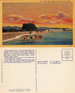
Vintage Postcards Showing Black Rock in the Great Salt Lake

More vintage postcards about the Great Salt Lake, these are specifically about Black Rock.

The first postcard is from the 1910s-1920s and the others are 1940s.

The second postcard is actually at Sunset Beach, which is just a smidge east of Black Rock. Sunset Beach is between Black Rock and the Great Salt Lake Marina.

And, as an FYI, the Great Salt Lake Marina is at Silver Sands Beach.

I didn’t realize until recently that we had named beaches


Vintage Postcards About the Great Salt Lake

“Greetings from the Great Salt Lake” is the topic of today’s #WestDesertWednesday

I like looking at old postcards to see how the landscape and people have changed. When looking at postcards about the Great Salt Lake there seems to have been quite a bit of human interaction with it in the past- both locals and tourists. Obviously, Salt Air was a hot spot but so was Black Rock (which I will post those images right after this one).

Now Black Rock is a lonely rock and is high and dry. The marina is unusable and all the boats have been pulled out. Those wood trestles of the Lucin Cutoff have been pulled out (and repurposed by a local).

And even the new Great Salt Air seems a lonely shadow of its past.

My guess is that most of these postcards are from the 1970s-1980s. The postcard showing the reading of newspapers in the lake is probably from the 1940s. And the new Great Saltair postcard appears to be from 1990s.


Source of images: personal collection and Ebay. 

20 August 2022

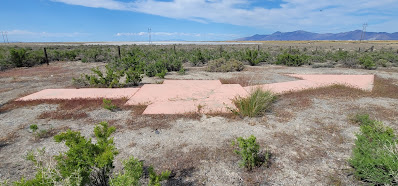
Concrete Arrow is a Remnant of a US Airmail Beacon Station, Timpie Junction in Skull Valley

US Air Mail arrow, north end of Skull Valley.
Designation SALT LK AWY BN 59.

This large concrete arrow in Utah’s West Desert is part of the old Post Office Airmail system. These arrows are scattered all over the country but this one is my favorite because access is easy in that 1) it is on public land, and 2) it is right off Exit 77 of I-80.

Just a few years after the Wright Brothers' first flight, airplanes were used sporadically to carry the mail. During WWI, significant advancements were made by the US Army (no Air Force until after WWII) in airplanes and they had proven their utility.

So, in 1918 the Post Office asked the Army to create a system to fly mail on a regular basis for faster delivery. The Army developed and ran the airmail for the first 3 months using converted Army planes.

The Army then handed the system off to the Post Office to manage. Initially airmail only ran in the eastern states but slowly the rest of the US was included.

By Sept of 1920, airmail was flown across the country, from NYC to San Francisco, but only by day because night flying was difficult due to the inability to see the railroad tracks that they typically followed. So, a national system of night beacons atop concrete arrows showing the way was developed to guide the pilots.

As usual, Utah’s West Desert was a challenge and took until 1929 to complete the east-west transcontinental route. Each arrow pointed the direction to the next arrow on the route, typically 10-15 miles away.

Atop the tower was a rotating beacon with 2 directional spotlights showing the proper direction. Red lights were chosen over white lights as they could be seen from a farther distance. Green lights were used when there was an emergency landing strip nearby.

Mail Arrow beacon layout.
Excerpt from Air Navigation by P. V. H. Weems 1938

This was the system the airmail used for decades. Innovations in the technology that aided pilots were constantly developing. And eventually, the air beacons became unnecessary.

The Timpie airmail beacon was dismantled in May 1965 along with several others in Salt Lake and Tooele Counties.

This arrow was painted orange by a local boy scout troop, about 2017. Historically the arrow would have been yellow.  

Arrow in May 2022

Here is how the arrow looked in 2016, before it was painted. 

And here are various maps of the airmail routes: 

United States Post Office Department map of air mail routes, 08/21/1928.
(Source)


Clip of the 1924 airmail route, showing Salt Lake City to Timpie, via Grantsville.
From US Army, Air Corps, US Army Corps of Engineers & Geological Survey, USTB. (1924) Aeronautical strip maps of the United States.
Source: Library of Congress, https://www.loc.gov/item/2009582531/.

There is lots of information available about these US Airmail beacons and their concrete arrows. The two sites I like are below:

Update Sept 1, 2022:
I added video directions to the arrow from Exit 77 of I-80 in Tooele County, Utah.


10 August 2022

Ancient Footprints Persevered in the Great Salt Lake Desert

Ancient footprints are preserved in the Great Salt Lake Desert.  An excavated footprint is in the foreground but you can also see unexcavated footprints (which appear like darker shadows in this image) in the background. July 2022.

Hill AFB recently announced a unique archaeological site in the GSL Desert on their South Bombing Range.

Named the Trackways Site, it consists of several tracks of human footprints likely dating to about 12,000 years ago.

Thousands of Paleo-age archaeological sites have been found in this area of the GSL Desert, including the famed Wishbone Site with a radiocarbon date on a fire hearth of 12,300 years ago. Although the finding of intact human footprints is surprising, it is in line with previous discoveries in the area.

The archaeologists are being cautiously optimistic about the authenticity of the find, citing more research is required.

I visited this site a short time before the official press release; I went in skeptical and left fairly convinced of its human antiquity. The stratigraphy is what ultimately convinced me.

Nowadays, that area of the GSL Desert is a wide-open alkali flat almost void of all flora and fauna, which means most people avoided it for most of the last 10,000 years.

The GSL Desert was once the bottom of Lake Bonneville in which fine silts were deposited on the lake floor. Then, during the waning years of Lake Bonneville, the area became a vast wetland fed by overflow water through the Old River Bed and springs, thus creating a vast wetland known as the Old River Bed (ORB) Delta.

The type of sediment deposited during each of these stages also changed from the fine silts of a deep lake to the sands and gravels transported by faster flowing streams.

These unexcavated footprints are inverted sand-filled prints. The sand erodes at a slower rate than the surrounding Lake Bonneville silt, These footprints are a part of a longer footprint trackway. July 2022.

The footprints themselves appear to have been formed when people walked in the shallow water of this ancient wetland. Their feet sunk through the sand into the underlayer of fine Bonneville silts, which were then filled in with the overlayer of sand after the foot was removed. Consequently, the footprints were preserved as sand-filled imprints, some of which are now exposed as inverted sand prints surrounded by alkali flats.

Here is the link to the original Hill AFB press release

08 August 2022

Lake Bonneville Animation

I made a thing! Of course, it is of my favorite Pleistocene-age closed-basin lake system = Lake Bonneville!


Also, I had to make a YouTube channel, so I guess you can check that out too.

26 August 2021

Native Hawaiian Neighborhood near Warm Springs in Salt Lake City


John W. Kauleinamoku was another early Native Hawaiian to immigrate to Utah. He was also a Mormon convert and came to SLC in 1875 (2 years after Kiha Ka’awa Nebeker) and was the first adult Native Hawaiian to permanently move to Utah making him the de facto leader of the emerging Native Hawaiian community in SLC.

Between 1872 and 1889, about 75 Native Hawaiians (all Mormon converts) settled in SLC. They mostly lived at the edge of town in the Warm Springs area of the Capitol Hill neighborhood, primarily between what is now 200-300 West and Reed and Fern Avenues.

Kauleinamoku’s house was the most well-known and hosted funerals, gatherings, and religious services conducted in Native Hawaiian. Many other Native Hawaiian immigrants lived with Kauleinamoku and his family in his small adobe home. 

The Kauleinamoku house was located at 754 N 300 West and was demolished about 2003 by the SLC Redevelopment Agency (RDA) (along with the Morrison Meat Pie facility); townhomes now occupy the site.

According to research done by Nelson Knight, there are at least 5 homes of early Native Hawaiian settlers that remain standing in the Capitol Hill neighborhood:
  1. Makaula house at 249 W Reed Ave
  2. Salamona Nui Kapiipiigm House at 222 W Fern Ave
  3. Solomona & Raanaana Umi house at 240 W Fern Ave
  4. A.H. Kapukini House at 226 W Fern Ave
  5. Peter Kealakaihomia House at 254 Fern Ave
Most Native Hawaiians had a difficult experience in Utah, primarily stemming from racial prejudice and stereotypes of Pacific Islanders perpetuated by syndicated newspaper stories that described them as cannibals, practitioners of infanticide, and lepers.

In June 1889, 4 Native Hawaiians applied for US Citizenship, but the Utah Supreme Court decided that Native Hawaiians were Polynesian and thus part of the Malay race and were not eligible for citizenship because of the Chinese Exclusion Act of 1882.

Largely in response to this ruling, and the general racial prejudices in obtaining work, about 50 of the 75 Native Hawaiians in SLC relocated to the new Hawaiian settlement of Iosepa in Skull Valley in Aug 1889. Most of the other either returned to Hawaii or eventually relocated to Iosepa as well. Kiha Ka’awa Nebeker (see previous post) seems to be an exception to this trend.

Kauleinamoku was also one of the leaders of Iosepa (although the formal Mormon Church leadership positions were all headed by White people, most of whom were previous missionaries to Hawaii).

Kauleinamoku died in 1899 at Iosepa. His grave site is enclosed by an iron fence at the Iosepa Cemetery.
 
Sources:
Knight, Nelson. This Old House Solomona & Raanaana Umi Property, Capitol Hill Neighborhood Council Bulletin, Nov 2009.

Knight, Nelson. This Old House: John Henry & Marie Kaoo Makaula House, Capitol Hill Neighborhood Council Bulletin, March 2005.

Kester, Matthew. “Race, Religion, and Citizenship in Mormon Country: Native Hawaiians in Salt Lake City, 1869-1889.” Western Historical Quarterly, vol. 40, no. 1, 2009, pp. 51–76. JSTOR, www.jstor.org/stable/40505603

Kester, Matthew. Remembering Iosepa: History, Place, and Religion in the American West. Oxford University Press. 2013.  


10 May 2016

Historic US Airmail Arrow in Skull Valley

A historic U.S. Airmail concrete arrow located in Skull Valley. This was used to mark the way for pilots during the 1920s. There would have been a tower with a lighted beacon for navigation at night.

This one is designated SALT LK AWY BN 59 and is located at the north end of Skull Valley, Tooele County, just off of Exit 77 on I-80.

Here is a good Google Map to find more.