Showing posts with label 200 South. Show all posts

03 February 2025

Franklin Avenue's Name Changed to Edison Street in 1906

In 1906, Franklin Avenue’s name was changed to Edison Street. It was a deliberate attempt by SLC government officials and property owners to change the racial make up of the street: from a residential area occupied nearly entirely by Black American families to a commercial district owned and operated by White businesses.
A 1906 newspaper article detailing the excitement of pushing out Black residents of Franklin Ave.

It was a deliberate decision to push an "undesirable" population out of the downtown area of Salt Lake City. Many of whom eventually relocated to the southern half of the Central City neighborhood, primarily south of 400 South and west of 500 East.

The name change was petitioned by property owners of Franklin Ave, who were primarily White individuals and descendants of the original Mormon/LDS Pioneers who settled this block.

The Black residents of the street were primarily renters (although one notable exception- Mr. H.H. Voss, more on him later) and had little say in the future of the neighborhood.

A direct newspaper article title: [The street] Changes Name and Color
 
The first business to move to Edison St was Skelton Printing, who purchased the old Franklin Avenue Theater building (more about that building later) and ghost sign remnants of the printing operation can still be seen on the building.

Additional White owned businesses moved in soon thereafter. Once a budding commercial district was established, Salt Lake City decided to invest in better utilities and beautification efforts. For example, Edison Street was paved in 1909 with cement and sidewalks were installed.

A 1910 photograph of one of the new businesses- Voyles Meat Market at 152 E 200 South.
 
The paving helped resolve sanitary issues of the often muddy street with poor drainage and the high number of older homes that had never been connected to the sewer line (outhouses were abundant).

With the understanding that 1906 marks a significant year in the history of this street, My next several posts will discuss the pre-1906 history (Franklin Avenue) and the post-1906 history (Edison Street): Important events. Significant buildings. Interesting history. So much history to highlight!

NOTE – there is a rumor going around that Edison Street was so named because it was the first street with electric lights in SLC. *This is false.* Main Street was the first electrified street in SLC as it was the showcase business street.

Franklin Avenue History all February


Explore the hidden history of SLC's old Franklin Ave, now known as Edison Street. Located between 200-300 South Streets and State St and 200 East. This mid-block alley was once a micro community of Black Salt Lakers.

I plan to highlight the history of this street during the month of February 2025.

04 January 2024

2023 Recap with Demolished Salt Lake Podcast

I was a guest on episodes 31 and 32 of the Demolished Salt Lake Podcast. “2023 Preservation Wins, Loses and What to Watch in 2024.”

We discussed some of the buildings we lost in 2023, the ones that were saved, and those that are in danger of demolition in 2024. We had more saves than losses this year, which was greatly needed after the past few years.

In this first of two parts, we talk about the loss of the Pink House and the Yardstick Building earlier this year. Discuss the status of the land on which some historic buildings used to stand in my “Still a Parking Lot” segment (ahem... the La France Apartments) and move on to buildings that will be demolished in 2024. Saving the best for last, we end with good news for a few of our historic buildings and areas.

We know we missed some buildings, but these are some of the standouts.

With – Wendi Pettett and Chris Jensen of Demolished Salt Lake Podcast and Adrienne White of House Genealogy

Photos of some of the highlights:

1. The Pink House (Covey House), 666 E 300 South SLC
2. Mountain Bell Building, 205 E 200 South SLC
3. Elias Harrison House, 10 N 300 West SLC
4. Cramer House, 241 Floral St SLC
5. Liberty Wells Center, 707 S 400 East SLC
6. Musser House, 2157 S Lincoln St SLC
7. 2nd Ward Assembly Hall, 483 E 700 South SLC
8. Jerald and Sandra Tanner House / Utah Lighthouse Ministries, 1350-1358 S West Temple SLC
9. Brinton House, 4880 S Highland Circle Holladay
10. Wells Ward Chapel, 1990 S 500 East SLC


04 April 2022

Angelo Caravaglia's Twin Bronze Sculptures on the Ma Bell Building

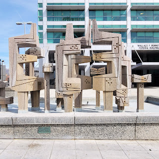
These twin bronze sculptures (fraternal, not identical) on the corner of 200 S and 200 East SLC at the old Mountain Bell building were created by noted Salt Lake City artist Angelo Caravaglia.

Bronze sculptures by Angelo Caravaglia, Mountain Bell building, 205 E 200 South Salt Lake City, 2022.

Mountain Bell (Ma Bell) Building 205 E 200 South SLC, 2022

Detail of the southwest corner of the Mountain Bell (Ma Bell) Building 205 E 200 South SLC, 2022. Note the unfortunate placement of a bus stop shelter and bike station in front of the sculptures.

 Caravaglia was born in 1925 to Italian immigrant parents in Erie, PA where at 9 years old he began carving soap with his pocketknife. He served in the US Army during WWII and when honorably discharged soon returned to his studies and to art.

When he was 31 years old, in 1956, the UofU recruited him to break up the stuffy Art Department where Caravaglia and fellow artist V. Douglas Snow brought some mid-century modernism to the U’s conservative sculpture department.

For years Caravaglia exhibited locally and throughout the art world, but it wasn’t until 1966 that regular Salt Lakers took notice of his art, and they didn’t much like what they saw. He was commissioned by the GSA of the federal government to create an art piece for the new Wallace F. Bennett Federal Building (125 S State).

Angelo Caravaglia, from Deseret News June 14 1966.

Angelo Caravaglia's sculpture in front of the Wallace F. Bennett Federal Building (125 S State) 

Although some Salt Lakers enjoyed Caravaglia sculpture at the Federal Building, most complained with one saying it looked like “a forest of monkey wrenches.” More on this piece later.

This poor reaction to Caravaglia’s work for the federal building in 1966 may be why there was little fanfare for the unveiling of Caravaglia’s sculptures at the Mountain Bell building in 1971. Only a single newspaper article noted it, and that was written by fellow University of Utah Art Professor, George S. Dibble.

Dibble described the bronzes as warm and intimate, a convincing theme of communication. Dibble continued: Figurative elements evolving from a strong central organism move out succinctly in vertical thrusts and in graceful lateral outsweeps. Modulated light falls gently on precise edges, dividing cleanly chiseled surfaces that return crisply to the wall. Central units are engaged in contrasts of palpable depth and flowing elements of conformation and change set up notions of continuing energy.

The sculpture was prepared in Styrofoam (a new material at the time) and plaster; it was cast in the bronze foundries at Pietrasanta, Italy.

Bronze sculpture on the east side of the Mountain States building.
 
Bronze sculpture on the south side of the Mountain States building
 
Caravaglia has several pieces in public and private collections along the Wasatch Front. You have likely seen his work and just not known who created it. More info at www.angelocaravaglia.com

Angelo Caravaglia's official portrait, from the artist's website.

At present, the new owner of the old Mountain Bell building is considering their options regarding the sculpture. Current plans are to reuse the building into a new housing project.

Sources
  • In Memoriam Angelo Caravaglia: 1925-2008. www.artistsofutah.org
  • The Morning Call Oct 12 1966
  • The Salt Lake Tribune Nov 28 1971
  • The Salt Lake Tribune May 25 1986
  • www.angelocaravaglia.com

29 March 2022

Brutalist Ma Bell Building

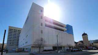
This Brutalist building at 205 E 200 South SLC was built 1969-1971 to house Mountain Bell’s growing administrative and data processing needs.

Mountain Bell data processing center, 205 E  200 South SLC. 2022.

The original configuration of the building, 1971. From Des News 1971-02-10

Mountain Bell was part of the “Ma Bell” companies originally founded by Alexander Graham Bell and then, much later, AT&T. Up until the 1983 monopoly breakup, Mountain Bell oversaw telecommunication in UT, CO, AZ, ID, MT, NM, and WY.

This building was constructed to house computer equipment used for billing, disbursements, record keeping, toll rating, accounting, and payroll. During the 1970s and 1980s, Mountain Bell was the 2nd largest employer in the state, Kennecott being the largest.

The building was designed by the architectural team Folsom and Hunt and later remodeled in the 1980s by Martin Brixen and James Christopher. 

The $7M (~$51M today) structure was originally 4 stories tall but had steel pilings to allow upward expansion to 15 stories. It was expanded in 1979 by elongating the 4th floor and adding 2 additional floors above. Notably, these additions have windows.

In 1980, Mountain Bell expanded again, building the 17-story blue-windowed office tower across the street at 250 E 200 South (250 Tower) and linked the two buildings' HVAC systems to allow the new office building to reclaim waste heat from the data processing building.

Mountain Bell fancied itself a progressive company, releasing its affirmative action plan in 1973 which essentially stated that anyone could work in any job.

Vice President Mack Lawrence later reflected that when he joined, it was a conservative company with clean-shaven faces and mandatory coat and tie. But by the 1980s the counterculture of the 1960s-1970s had gained more acceptance and beards on men and pants on women were acceptable! The company even boasted about a few male telephone operators and women installers, a field job previously closed to anyone who shouldn’t wear pants.

The last occupant of the building was CenturyLink. Thus far, the current owner plans to incorporate the existing building into a new residential building.

Overview, southwest corner, Mountain Bell building. 2022.

Overview west elevation, Mountain Bell building. 2022.

NYT advertisement of a 1971 IBM computer system

Detail of Bell logo on main doors of the Mountain Bell building, 2022.

Next post will be on the two Angelo Caravaglia sculptures.

Sources:

  • Salt Lake Tribune 1968-04-18
  • Salt Lake Tribune 1970-02-22
  • Deseret News 1970-11-23
  • Salt Lake Times 1973-06-15
  • Salt Lake Tribune 1978-11-15
  • Salt Lake Tribune 1980-11-21
  • Salt Lake Tribune 1982-02-21
  • Salt Lake Tribune 1989-03-24
  • SAH-archipedia.org
  • Snowbird.com/blog


28 March 2022

Bronze Sculptures on a Brutalist Building

Salt Lakers will likely recognize this bronze sculpture attached to a brutalist building. The history of this sculpture was a bit difficult to track down but once I did it turned out to be rather significant. I will post more about the sculpture and the building tomorrow. (I need to write it up tonight).

10 February 2022

Franklin Avenue

Franklin Avenue will be the subject of my next series of posts.
 
Currently, the mid-block alley is known as Edison Street but before 1906 it was Franklin Ave and it was the area that housed most Black people in SLC.

Specifically the northern extent between 200 South and 300 South and between State St and 200 East (Block 56).

31 December 2021

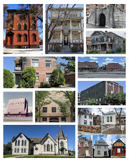
Some historic buildings that were saved from demolition in 2021


These are some of the historic buildings that were saved from demolition in 2021! Visit @demolishedsaltlakepodcast for some buildings that were lost this year.
 

Descriptions clockwise from the upper left corner:

1. Hyland Exchange, 847 S 800 E SLC. It will be converted to housing. But, 2 Victorian homes were demolished.

2. The Annex Apts, 150 E South Temple SLC. A project plans to rehab the Annex but it also demolished the Carlton Hotel next door.

3. Elks Block, 139 E South Temple SLC. Most buildings will be preserved, the Elks building will be renovated, the Elks tunnel entrance will be partially preserved.

4. House at 235 S 600 E SLC. The owner plans to add an addition to the back of the house and start repairs and rehab of the rest of the house.

5. Utah Pickle and Hide buildings at 737-741 S 400 W SLC. Some selective demolition has occurred but the main buildings are planned to be rehabbed.

6. Central Warehouse at 520 W 200 S SLC. The back half of the building has been demolished; the remaining front is to be integrated into a multi-use development.

7. These 5 houses on 200 East were subject to a rezone application which would result in their demolition. The rezone was not approved, and the houses are now being repaired.

8. 15th Ward Chapel at 915 W 100 S SLC was listed for sale which could have resulted in demolition; it was purchased by the Utah Arts Alliance and is now known as the Utah Art Castle.

9. Redwood Drive-In and Swap Meet at 3688 S Redwood WVC was proposed for demolition for a large housing project. Largely due to the backlash from the swap meet community the prospective owner decided to cancel the sale and development.

10. University of Utah’s Einar Nielsen Fieldhouse has undergone a seismic retrofit and will be converted to a theater.

11. Apt complex at 230 West 300 North SLC will be preserved while the area behind it will become additional multi-family housing.

It is important to note that only 2 of these projects had local historic preservation requirements for the property. All the others were only preserved because the owners desired it.

A big thanks to the owners, architects, engineers, and builders who all worked to keep some of Utah’s history standing.

24 October 2021

The Tanned Human Skin at the SLC Police Department

The SLC Police Dept has held onto a strip of tanned human skin for 100 years.

The story begins with a criminal going by the name of Tom “Blackie” Burns. He had several recent aliases including Tom Miller and Tom Gleason but his real name was Joseph C. Alseimer and originally hailed from Madison, Wisconsin where he was well known for his long list of crimes, including a successful jailbreak in 1917.

After his escape from Wisconsin, he came west and went by a variety of his “Tom” aliases throughout several western states.

In the early morning hours of Feb 8 1921, Tom and his gang of 3 others broke into the J.C. Penney store at 225 S State St. Their activity was reported by a nearby hotel clerk and Tom’s gang soon found themselves confronted by Detective C. W. Roskenkrantz, a rooky on the SLC police force. Tom and his gang quickly overpowered Rosenkrantz, tied him up, beat him unconscious, and took his service revolver.

Police reinforcements soon arrived and captured the 3 other members of Tom’s gang. But Tom had escaped by jumping out a window and went to the nearby Nord Hotel at 59 E 200 South (now the Gallivan Center) where he had rented a room.

Tom’s gang immediately confessed, and the police soon raided the Nord Hotel looking for Tom. During the raid, Tom shot and killed SLC Police Detective Green Hamby and wounded Chief of Police Joseph E. Burbidge. Burbidge then shot Tom in the chest who died an hour later at the hospital. You can find a memorial plaque for Detective Green at the Gallivan Center.

No one claimed Tom’s body, so it was sent to the University of Utah Medical School for dissection and educational purposes.

One version of the removal of Tom’s skin says that it was removed by the university and presented to the police who then hung it on the wall in the evidence room.

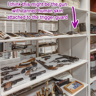
Another version says that off-duty police officers snuck into the police morgue and removed the skin, tanned it, and then looped it on the trigger guard of the pistol Tom had used to kill Hamby and wound Burbidge.

By 1993 the gun with Tom’s tanned flesh wrapped around the trigger guard was on display at the Police Museum in the old Public Safety Building (315 E 200 South).

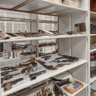
I recently visited the new Police and Fire Museum in the new Public Safety Building (475 S 300 East) and did not see Tom’s skin on display (probably a wise decision). However, I believe a photograph published in 2014 by the SpaceSaver Corporation showing off its museum shelving system does show the notorious flesh-wrapped weapon.

Sources:
Salt Lake Telegram 1921-02-14; SL Telegram 1935-01-05; Deseret News 1993-08-29; End of Watch by Robert Kirby 2004; Case Study: SLC Public Safety Building by SpaceSaver Corp 2014; various vital records on Ancestry

Image showing the SLC Police Museum collections shelving system, from SpaceSaver Corp, 2014

Image showing the SLC Police Museum collections shelving system, SpaceSaver Corp, 2014, with my notes

Tom "Blackie" Burns, real name Joseph C. Alseimer

Memorial plaque for Detective Green G. Hamby, on display at the Gallivan Center, SLC.

12 July 2021

The Stockade: SLC's Officially Sanctioned Red-Light District, 1908-1911

North entrance to the Stockade on 100 South of Block 64, 1911.
Dora Topham (Belle London) kept her office in the one story
building just left of the two individuals.
Photograph taken from 564 West 100 South. From UDSH.

In 1908, most of SLC’s Block 64 in the emerging GreekTown (see previous post) became SLC’s new red-light district known as The Stockade.

Prostitution was not new to SLC and an unofficially controlled form of prostitution (where sex workers were arrested, paid a monthly fine, and were set free to do it all again) was practiced in SLC since 1870.

What made the Stockade different was that it was officially sanctioned, developed, and protected by the Mayor, City Council, and Chief of Police; and it was run by a single Madame. That woman was Dora Topham, more popularly known as Belle London.

SLC Chief of Police, Thomas Pitt, first suggested formally regulating prostitution in his annual report of 1907. While the newspapers and anti-vice groups initially dismissed the idea, mayor John S. Bransford and the City Council (most were members of the American political party) quietly started implementing the plan.

Bransford said, at least publicly, that moving the red-light district from Commercial Street (now Regent Street) where it had existed since the 1870s would allow the downtown business district to thrive in more respectable endeavors. Privately, Bransford and some City Council members had plans in the works to profit from the move.

Block 64 (100-200 S / 500-600 W) was chosen for the Stockade as it was near the railroad tracks, away from schools, and had existing utilities and infrastructure within the inner block: namely Boyd Court and Carter Terrace.

In addition, the neighborhood was transforming into GreekTown and “most of the better class of residents were leaving” as more Greeks, Italians, and Japanese were moving in. Thus, according to SLC’s leadership the new immigrants had already destroyed the respectable nature of the neighborhood and establishing the red-light district would not harm it further.
Constructing the cribs in 1908.On 200 South looking into the interior of the block, from UDSH


Constructing the cribs in 1908.On 200 South looking into the interior of the block, from UDSH

In May 1908, parts of Block 64 were purchased or leased by The Citizens Investment Co, which was a newly created company almost entirely operated by Dora Topham (aka Belle London) who served as the President, Treasurer, and General Manager.

Topham was described as “an extremely clever woman” and brought in from Ogden where she was well known for being a Madame. More about her later.

The Citizens Investment Co began construction in the summer of 1908. A 10-foot wall surrounding the Stockade was built with entrances at the north and south sides of the block. Existing houses were converted into brothels and rows of new cribs were built. New buildings for saloons and stores were built primarily along 200 South, including the soon to be demolished Citizen Investment Co building at 540 W 200 South.

The existing residents of Block 64 opposed the new Stockade and they organized as the West Side Citizens League and made formal complaints to the City Council. They filed a lawsuit to stop the opening of the Stockade and won with an injunction being issued, which was then completely ignored by the City.

In Dec 1908 the Stockade formally opened and pressure was placed on the Commercial Street Madams to move locations. A few of the Madams moved to the Stockade, a few closed shop and left town, and a few persisted and remained open on Commercial Street through the Stockade years.

Those opposing the Stockade eventually won a legal battle that stuck and Topham was sentenced to 18 years of hard labor for inducing a woman into prostitution (later reversed by the Utah Supreme Court). In response Topham abruptly closed the Stockade in Sept 1911 and sold her property, eventually moving to California.

The occupants of the Stockade either returned to Commercial Street or remained on the west side of 200 South. Commercial Street remained a red-light district until the late 1930s and 200 South remained one until the late 1970s.

Map of the Stockade from Jeffrey Nichols book Prostitution Polygamy and Power.
Color highlights added for clarity. 

Overlay of the Stockade from 1911 Sanborn onto modern Google Map 2020.
 Green show modern landmarks; Yellow show Stockade features.

Sources: Prostitution, Polygamy, and Power: Salt Lake City 1847-1918 by Jeffrey Nichols; Red Lights in Zion: SLC Stockade 1908-11 by John S McCormick in UHQ V50, 1982, N2.

09 July 2021

The Development of Block 64 into SLC's GreekTown

Block 64 (100-200 South and 500-600 West) is situated north of the TRAX Old GreekTown station. This post explores how Block 64 and the surrounding area transformed into Salt Lake's GreekTown.

When SLC was first platted in 1847 the 10-acre blocks were laid out in a grid pattern with Block 1 situated at SE corner of the city, at what is now 800-900 South and 200-300 East. Block 64 is located at what was then the western edge of the City.

Lots were divided among those early Mormons with the widow Nancy Baldwin’s family getting 2 lots on Block 64, the entire southwest quadrant of the block. When George W. Boyd married into the Baldwin family (he married 3 of Nancy’s daughters) those lots and others that he eventually purchased became known as the Boyd property.


For several decades Block 64 remained as much of the rest of SLC– sparsely spaced adobe homes with each house having room for gardens, orchards, and farm animals.

Street in Great Salt Lake City, about 1850s. From LOC.

The first railroad tracks were constructed to SLC in 1870 and in the next couple decades the railroad greatly expanded its operations and was a major employer on the west side of SLC. Even George Boyd, as an old man, worked for the railroad.


Bird's eye view of Salt Lake City, Utah Territory 1870. From LOC.

After more than 40 years of owning property on Block 64, George started selling his property to his children (and others) in the 1890s. William B. Boyd built tenements behind the adobe homes and named the area Boyd Court, which was later called Boyd Ave when the area became known as the Stockade.

Other property owners on Block 64 and surrounding areas were also building rental units and commercial spaces in the 1890s; notably A. R. Carter who built the large Carter Terrace on the north central side of Block 64 that was later converted to brothels (more on that later).

The 1890s also brought city utilities such as electricity, water lines, and sewer line to Block 64; paved streets came in 1902.

In the 1890s the property owners were still largely Mormon with about half of the buildings on Block 64 being older adobe homes. But some new elements, such as the Westminster Presbyterian Church, had started moving in and the neighborhood had begun its transformation.


Salt Lake City, Utah 1891. From LOC.

In 1900, there were only 3 Greek people recorded living in Utah. By 1910 there were 4,062 and they eventually became the largest labor force in the State. Poor conditions back in Greece encouraged immigration to America in the early 1900s.

Between 1900-1905 Block 64, and other surrounding areas, developed rapidly into a Greek enclave mostly due to Greek labor agents such as Leonidas Skliris and Nicholas Stathakos who brought in their countrymen to work the nearby mines and railroad.

In 1905 the Greek community had built its first church in SLC- the Holy Trinity Greek Orthodox Church located at 439 W 400 South (now demolished), the precursor to today’s Holy Trinity Cathedral built in 1923 (279 S 300 West).
 
 The first Greek Orthodox Church located at 439 W 400 South (now demolished) in 1908. From UDSH.

Most of the Greek immigrants were male who sent money back their families in Greece. Only a few Greek Salt Lakers were able to send for their wife and children to join them in SLC. A fair number of Greeks were able to pay for the travel of brides picked by their family back home.

Greek wedding of Magna residents Angelo Heleotes
at SLC’s first Greek Orthodox Church, 1915. From UDSH.
 
By 1908 the west side of 200 South had become known as GreekTown and, not coincidentally, SLC leadership decided to move the Red-Light District to Block 64 to try and break up the enclave of “undesirable” Greeks congregating in that area (among other reasons). More on that later.

The 1910s and 1920s were the peak of SLC’s GreekTown. Much like the rest of SLC’s downtown and other ethnic neighborhoods of SLC, the 1950s and 1960 saw decline through the elimination of public transportation and the emphasis on building up the suburbs.

Open Heart Coffeehouse in SLC GreekTown at 548 W 200 South; Proprietor Michael J Katsanevas is standing, ca 1920. From UDSH.

A note on this image:
This photo shows the Citizens Investment Co Building when it was used as
a Greek coffeehouse (later the Café Orbit/Metro Bar) and soon to be demolished.
Thanks to a great-granddaughter of Katsanevas for updated and correct info! 


Sources:
-  For more about the first platting of SLC: Cartography and the Founding of Salt Lake City by Rick Grunder and Paul E. Cohen. UHQ V87 N3, 2019.
- For more about Greeks in Utah: Toil and Rage in a New Land: The Greek Immigrants in Utah by Helen Papanikolas, UHQ V38 N2, 1970.

29 June 2021

Demolition of the Last Remaining Building from “the Stockade”

Citizen Investment Co building at
540 W 200 South SLC, June 2021.

This building at 540 W 200 South will be demolished as part of the Cinq Apartments, the same construction project that plans to preserve most of the nearby Central Warehouse building (see previous post).

This unassuming building has a sordid history and is the last remaining building from “the Stockade,” Salt Lake’s officially sanctioned red-light district built and managed in 1908 by Dora Topham, aka the Madame Belle London. 

The building is named the Citizens Investment Co building because that was the legal entity that was established by Dora Topham to purchase the land, build the stockade, and manage other matters.

There are a lot of stories associated with this building and plot of land.  Before this building was constructed in 1908 it was the location of George W. Boyd’s adobe house- he built Boyd’s Pony Express Station in Utah’s West Desert, which remains today as one of the best-preserved Pony Express Sites.  George was a Mormon polygamist with 3 wives and 15 children. 

Exploring how Boyd’s property and the surrounding blocks morphed from small Mormon Pioneer adobe houses into GreekTown should be interesting.

This also seems to be a good time to explore the life of Dora Topham; she made quite the impact in Ogden but was only in SLC a few years.  Plus, she is the namesake for London Belle Supper Club.

And then there is the red-light district itself. What did it look like (and smell like?) and what was it like for the women who lived and worked there.  What did GreekTown think of their new neighbors? 

What other things interest you about this property and the stories around it? Maybe I will find out for you during my deep dive and share more interesting stories about SLC’s past.

There will likely be a few interesting posts to come out of this topic so stick around.

In the meantime, swipe to read the historical marker attached the building. I always stop and read the plaque!