 |
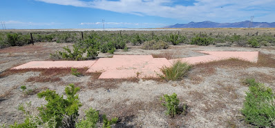
| US Air Mail arrow, north end of Skull Valley. Designation SALT LK AWY BN 59. |
This large concrete arrow in Utah’s West Desert is part of the old Post Office Airmail system. These arrows are scattered all over the country but this one is my favorite because access is easy in that 1) it is on public land, and 2) it is right off Exit 77 of I-80.
Just a few years after the Wright Brothers' first flight, airplanes were used sporadically to carry the mail. During WWI, significant advancements were made by the US Army (no Air Force until after WWII) in airplanes and they had proven their utility.
So, in 1918 the Post Office asked the Army to create a system to fly mail on a regular basis for faster delivery. The Army developed and ran the airmail for the first 3 months using converted Army planes.
The Army then handed the system off to the Post Office to manage. Initially airmail only ran in the eastern states but slowly the rest of the US was included.
By Sept of 1920, airmail was flown across the country, from NYC to San Francisco, but only by day because night flying was difficult due to the inability to see the railroad tracks that they typically followed. So, a national system of night beacons atop concrete arrows showing the way was developed to guide the pilots.
As usual, Utah’s West Desert was a challenge and took until 1929 to complete the east-west transcontinental route. Each arrow pointed the direction to the next arrow on the route, typically 10-15 miles away.
Atop the tower was a rotating beacon with 2 directional spotlights showing the proper direction. Red lights were chosen over white lights as they could be seen from a farther distance. Green lights were used when there was an emergency landing strip nearby.
 |
| Mail Arrow beacon layout. Excerpt from Air Navigation by P. V. H. Weems 1938 |
This was the system the airmail used for decades. Innovations in the technology that aided pilots were constantly developing. And eventually, the air beacons became unnecessary.
The Timpie airmail beacon was dismantled in May 1965 along with several others in Salt Lake and Tooele Counties.
This arrow was painted orange by a local boy scout troop, about 2017. Historically the arrow would have been yellow.
 |
| Arrow in May 2022 |
Here is how the arrow looked in 2016, before it was painted.
And here are various maps of the airmail routes:
 |
| United States Post Office Department map of air mail routes, 08/21/1928. (Source) |
  |
Clip of the 1924 airmail route, showing Salt Lake City to Timpie, via Grantsville. From US Army, Air Corps, US Army Corps of Engineers & Geological Survey, USTB. (1924) Aeronautical strip maps of the United States. Source: Library of Congress, https://www.loc.gov/item/2009582531/. |
There is lots of information available about these US Airmail beacons and their concrete arrows. The two sites I like are below:
Update Sept 1, 2022:
I added video directions to the arrow from Exit 77 of I-80 in Tooele County, Utah.
No comments:
Post a Comment