Showing posts with label Military. Show all posts

06 July 2024

WWI 1918 Military Draft Map of Salt Lake City

More map fun! This is a World War I (WWI) 1918 military draft map of Salt Lake City. This map shows men where they needed to go to register for military service, both citizens and non-citizens.

Clip of map from SL Trib 1918/06/04 Page 11

Detail of the same (above) clip of map from SL Trib 1918/06/04 Page 11

Of interest, the Japanese Association Headquarters building at 168 S West Temple is specifically noted and marked. The Japanese Association was the precursor to the Japanese American Citizens League (JACL).

The building at 168 West Temple was part of Salt Lake’s old Japantown which was mostly demolished for the construction of the Salt Palace in the 1960s.

Image 3 shows what the building looked like in 1918. The “Lodge Pool Hall” is the location of the Japanese Association. As it was mostly a fraternal association of men, it is sometimes identified as a Lodge.

I’ve denoted the approximate location of this building on the other images by using a torii gate icon in red.

Image of the building at 168 S West Temple in 1918. From USHS Shipler 18591.

Clip from a postcard of the Salt Palace in the 1960s

 Modern Google Maps showing the Convention Center in downtown Salt Lake City.

11 November 2022

The old Veterans Hospital at 12th Ave and E St is now the Meridien Condos

Old Veterans Hospital in 2022, as Condos
Veterans Hospital ca 1930s. Image from UDSH

This is the old Veterans Hospital at 401 E 12th Avenue (roughly 12th Ave and E Street) in Salt Lake City is now the Meridien Condos at Capitol Park.

Built-in 1932 in a neoclassical style, this 5 ½ story brick building was originally set back from the street on a steep hill and surrounded by park grounds. A smaller 3-story annex was added in 1939.

The newly created Veterans Administration (VA) recognized a need for a hospital in SLC to care for WWI and Spanish-American War veterans Architectural plans were drawn up in 1930 and site selection began.

Originally it was thought that the VA hospital should be located close to Fort Douglas but the VA decided on a residential area high on the North Bench (the Avenues) which provided cooling canyon breezes and was situated above the city smog.

Postcard showing the Salt Lake City Veterans Hospital

Postcard showing the Salt Lake City Veterans Hospital

More than 3 city blocks were purchased and construction was completed in June 1932.  The first patient, WWI vet Oliver J. Hunter, was admitted on July 1, 1932. Once fully opened, the hospital provided beds for 104 patients.

Built during the Great Depression, the hospital was seen as a method to provide good jobs to hard-hit Utahns, both during and after construction. Later the Works Progress Administration (WPA) provided labor tending to the grounds surrounding the hospital.

The hospital boasted state-of-the-art facilities including dentist care, an x-ray department, surgery, dining rooms, and a dietary kitchen. During WWII, the focus of the Veterans Hospital became vocational rehabilitation and physical therapy.

Veterans Hospital group, Christmas Day 1942. Image from UDSH.

Returning Soldiers from WWII greatly outpaced the SLC Veterans Hospital and the US Army opened the much larger Bushnell Hospital in Brigham City in 1942. And in 1946 SLC was approved for a new VA facility with construction work starting in 1950 on part of the Fort Douglas Military reservation; this new VA Hospital was opened in 1952 and is the current main campus of the SLC VA hospital system at 500 Foothill Blvd.

In 1962 the old Veterans Hospital in the Avenues neighborhood was closed to patients and was soon declared surplus. In December 1964 the property was purchased by the LDS Church and used the old hospital as an annex to its Primary Children’s Hospital. The LDS Church sold it in 1987 to IHC Hospitals Inc and when the new Primary Children Hospital was built in 1990.

Most of the land (28 acres) surrounding the old Veterans Hospital was subdivided and sold to developers. The hospital and a few surrounding acres were retained and the building was used intermittently but was primarily vacant for 16 years.

Veterans Hospital as it looked in 1996, Image from NRHP file, National Archives.

Veterans Hospital as it looked in 1996, Image from NRHP file, National Archives.

Veterans Hospital as it looked in 1996, Image from NRHP file, National Archives.

Veterans Hospital as it looked in 1996, Image from NRHP file, National Archives.

Veterans Hospital as it looked in 1996, Image from NRHP file, National Archives.

Veterans Hospital as it looked in 1996, Image from NRHP file, National Archives.

In 2004 it was purchased by Pembroke Capitol Park and converted to luxury condominiums through historic adaptive reuse, done by Hogan Construction at a cost of $20M. The interior was gutted, an underground parking structure was added, and the exterior was preserved. The condo conversion was completed in 2008.

Images of the renovation, from Hogan Construction.

Images of the renovation, from Hogan Construction.

Images of the renovation, from Hogan Construction.

Images of the renovation, from Hogan Construction.

In 1988 the building was shown in the movie Halloween 4 as Smiths Grove Sanitarium.

Of Note:
It is likely that the Veterans Hospital on 12th Avenue was segregated. The Tuskegee Hospital for Sick and Injured Colored World War Veterans in Tuskegee Alabama opened in 1923 and was the only Black Veterans hospital until 1954.

During the 1920s and 1930s, the Veterans Administration allowed hospitals to choose their segregation status based on local and regional practices, which for Salt Lake City would mean Black Soldiers would be in a separate ward or not allowed at all. My guess is the latter.

President Truman desegregated the US military through Executive Order 9981 but the VA kept most hospitals segregated in some form through 1953. On July 28, 1954, the VA formally announced that segregation had been eliminated at all VA hospitals.

So far, I’ve only seen white men as patients in the 1940 Census. Write a comment if you know of any specifics on the SLC Veterans Hospital policy on segregation.

Source: History of the VA in 100 Objects: number 11.   https://www.va.gov/HISTORY/100_Objects/Index.asp

Sources:

  • Salt Lake Telegram Nov 6 1931
  • Salt Lake Tribune July 2 1932
  • Salt Lake Tribune July 8 1932
  • Salt Lake Telegram July 14 1932
  • Deseret News Sept 14 1932
  • Salt Lake Telegram Sept 9 1933
  • Salt Lake Tribune July 6 1947
  • Deseret News Oct 7 2005
  • Salt Lake Tribune Aug 10 2006
  • Veterans Hospital NRHP File, NPS
  • History of the VA in 100 Objects: number 11

28 September 2022

These trail markers tell the story of historic migrations and explorations in their own words

Trail marker at the summit of Dugway Pass, Dugway Mountain Range, Utah

In my last #WestDesertWednesday post I talked about the U.S. Army’s Capt. James H. Simpson’s 1859 expedition to map an overland route heading west from Salt Lake City and Camp Floyd, a decade before the joining of the railroads at Promontory Point in 1869.

This route was utilized by the Pony Express (mail stations began to be established in 1858 and were in operation 1860-1861), Overland Stagecoach (1860s-1890s or so), Lincoln Highway (1913+), and in some places U.S. Route 40 (1926+). It was a successful route because it avoided the mucky Great Salt Lake Desert (ahem… Donner Party) and utilized the many natural springs in the area.

Eventually, this route was abandoned in favor of what is now Interstate 80 across the Salt Flats…. The creation of that cut-off route is a complicated story in and of itself.

Nowadays, you can drive much of Simpson’s original route through Utah’s West Desert, and I plan on showcasing several interesting stops along the way.

These historic trail markers are found along the various historic trails. They provide a brief excerpt from written reports of the original explorations. These markers are established and managed by the Utah Chapter of the Oregon-California Trails Association (OCTA). https://www.utahcrossroadsocta.org

Here are a few that I saw along a recent weekend trip through Utah’s West Desert.


The 2 maps shown here are taken from BLM publications on the Pony Express in Utah.


20 August 2022

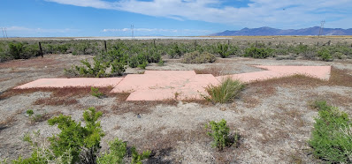
Concrete Arrow is a Remnant of a US Airmail Beacon Station, Timpie Junction in Skull Valley

US Air Mail arrow, north end of Skull Valley.
Designation SALT LK AWY BN 59.

This large concrete arrow in Utah’s West Desert is part of the old Post Office Airmail system. These arrows are scattered all over the country but this one is my favorite because access is easy in that 1) it is on public land, and 2) it is right off Exit 77 of I-80.

Just a few years after the Wright Brothers' first flight, airplanes were used sporadically to carry the mail. During WWI, significant advancements were made by the US Army (no Air Force until after WWII) in airplanes and they had proven their utility.

So, in 1918 the Post Office asked the Army to create a system to fly mail on a regular basis for faster delivery. The Army developed and ran the airmail for the first 3 months using converted Army planes.

The Army then handed the system off to the Post Office to manage. Initially airmail only ran in the eastern states but slowly the rest of the US was included.

By Sept of 1920, airmail was flown across the country, from NYC to San Francisco, but only by day because night flying was difficult due to the inability to see the railroad tracks that they typically followed. So, a national system of night beacons atop concrete arrows showing the way was developed to guide the pilots.

As usual, Utah’s West Desert was a challenge and took until 1929 to complete the east-west transcontinental route. Each arrow pointed the direction to the next arrow on the route, typically 10-15 miles away.

Atop the tower was a rotating beacon with 2 directional spotlights showing the proper direction. Red lights were chosen over white lights as they could be seen from a farther distance. Green lights were used when there was an emergency landing strip nearby.

Mail Arrow beacon layout.
Excerpt from Air Navigation by P. V. H. Weems 1938

This was the system the airmail used for decades. Innovations in the technology that aided pilots were constantly developing. And eventually, the air beacons became unnecessary.

The Timpie airmail beacon was dismantled in May 1965 along with several others in Salt Lake and Tooele Counties.

This arrow was painted orange by a local boy scout troop, about 2017. Historically the arrow would have been yellow.  

Arrow in May 2022

Here is how the arrow looked in 2016, before it was painted. 

And here are various maps of the airmail routes: 

United States Post Office Department map of air mail routes, 08/21/1928.
(Source)


Clip of the 1924 airmail route, showing Salt Lake City to Timpie, via Grantsville.
From US Army, Air Corps, US Army Corps of Engineers & Geological Survey, USTB. (1924) Aeronautical strip maps of the United States.
Source: Library of Congress, https://www.loc.gov/item/2009582531/.

There is lots of information available about these US Airmail beacons and their concrete arrows. The two sites I like are below:

Update Sept 1, 2022:
I added video directions to the arrow from Exit 77 of I-80 in Tooele County, Utah.


24 June 2022

Soil Collection Ceremony From the 2 Lynching Sites in Salt Lake City

Jars full of soil from the lynch sites of Thomas Coleman and William Harvey.


On Saturday, June 11, 2022, I participated in the Soil Collection Ceremony for the 2 lynchings that occurred in Salt Lake City's past. 

Soil from the lynching sites were collected, placed in labeled jars, and then sent to the Equal Justice Initiative’s (EJI) Legacy Museum in Alabama to join the other jars of soil from lynching sites around the country.

The two Black men lynched in SLC are Thomas Coleman and William Harvey.

Mr. Thomas Coleman
Thomas Coleman arrived in SLC in the early 1850’s as a slave with a party of Southern LDS slave-owners who were traveling to and settling in Utah. He subsequently worked for Brigham Young at the Salt Lake House hotel in downtown SLC and is believed to have joined the LDS faith.

The exact circumstances surrounding Coleman’s murder remain a mystery. What is known is that on Dec 11, 1866 several boys playing on Arsenal Hill (now Capitol Hill) overlooking SLC found his body. With his own knife, Coleman was stabbed in the chest twice and his throat was cut so deep that he was nearly decapitated. A sign was also left on his body that read, “Notice to all N*****s. Take warning. Leave white women alone.” He was 35 when he died.

The soil collection ceremony started at the steps of the Utah State Capitol, within view of the site of Thomas Colemans's murder (now the southwest lawn of the Capitol building).  

Ceremony at the Utah State Capitol. The lynching site of Thomas Coleman is on the southwest side of Capitol Hill.

Soil collection spoons for Thomas Coleman.

My spoon with soil at the flag marking the lynching site of Thomas Coleman on Capitol Hill.


Literature from the Equal Justice Initiative (EJI). This report of Lynching in America is on the EJI website


We then marched from the Utah State Capitol Building to the Wallace F. Bennett Federal Building at 125 S State Street, the location of the Old City Hall building (which was moved to Capitol Hill and now serves as the Utah Office of Tourism).  

Mr. William "Sam Joe" Harvey
William Harvey (sometimes “Sam” or “Sam Joe” because he served "Uncle Sam" in the US Army) arrived in SLC in early August 1883. Little is known about his life prior to that point. He came from Pueblo, Colorado. He was an Army veteran about 35 years old and tall with an athletic build. Harvey set up a bootblack stand on Main Street. He was described as irritable and some worried about his mental health.

On August 25, 1883, just weeks after his arrival, Harvey got into an argument with F. H. Grice, a local Black restaurant owner; Harvey allegedly pulled a gun on Grice but then fled the scene without harming anyone. Harvey was soon confronted by the SLC Police, whereupon Harvey is alleged to have shot 2 police officers, of which one died. Harvey was tackled, taken into custody, and led two blocks away to City Hall (now the location of the Wallace F Bennet federal building).

A crowd quickly devolved into a mob demanding blood for the slain officer. Other police officers, after beating Harvey, turned him over to the mob that grew to an estimated 2,000 who then secured a rope around Harvey’s neck and hung him from a rafter of the jailhouse stable, adjacent to City Hall, where he died slowly and fighting for his life. After Harvey died, the crowd then drug his body down State Street for several blocks.


 Lynch site of William Harvey, previously the site of the Old City Hall and Jail and now the site of the Wallace F. Bennett Federal Building. The lynching site is near the SW portion of the building.

The story of William Harvey’s lynching told by @blackmenaces

Me, adding soil to William Harvey’s jar.

I also took the suggestion to use my hands to feel the soil when filling the jar. 

My hands with soil from the site of William Harvey’s lynching. 


The courtyard at the Wallace F Bennett federal building is near the lynching site of William Harvey. 


A small rose garden grows along the edges of the courtyard. This is a relatively quiet reflection spot. I think I will write to someone (GSA?) to recommend more roses be planted. 


Save Utah's Black History. And Tell the Story. Sema Hadithi Foundation.

I am part of the Sema Hadithi Foundation, and I hope you will read about them, sign up for the newsletter, and share some of the many storieshttps://www.semahadithi.org/

21 January 2022

Utah was one of the last states to fully allow Native American citizens to vote

Soon after Utah became a state, Utah passed a law in 1897 that prohibited Native Americans living on a reservation from voting with the justification that they were not residents of the state of Utah. That law continued to be enforced until the Ute Tribe challenged it in court in 1956.

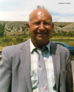
Preston Allen (1913-1989) was a 41-year-old Ute rancher chosen to be the voting rights test case. As a youth, he attended the Riverside Indian Boarding School and served 4 years in the US Army during WWII, rising to the rank of SGT. In 1956 he lived in Altonah on the Uintah and Ouray Reservation and was the Vice President of the Affiliate Ute Citizens group.

Preston V. Allen, ca. 1980s

Preston V. Allen during WWII.
  
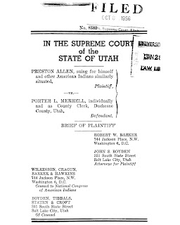
Preston asked for an absentee ballot from the Duchesne County Clerk, Porter Merrell, to vote in the 1956 election. Following the Utah Attorney General’s directive, his request was denied as he was living on a reservation.

In 1956, Allen v Merrell was heard by the Utah Supreme Court who decided that the 1897 law did not deny the right to vote on the basis of race (a clear violation of the equal protection clause).

Rather, the court decided that reservations (both miliary and Native American) were under the control of the federal government, so state and county elections were not applicable there and that Native Americans had a very limited interest or understanding of government and they should not be involved with state politics.

Most telling, however, was the court also expressed fear that Native Americans might outnumber the White voters.

The case was appealed to the US Supreme Court but before it was heard the Utah Legislature amended the 1897 law, making Utah the second to last state to allow on-reservation Native Americans the right to vote (North Dakota did so in 1958).


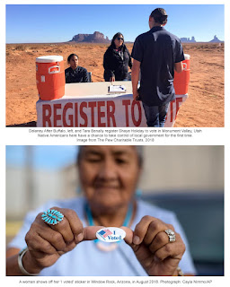
Unfortunately, this was not the end of voting restrictions on Utah’s Indigenous people. The Ute continued to have problems in Duchesne County. The Navajo in San Juan County also have difficulty as demonstrated by a 2018 lawsuit settlement with requires San Juan County to implement corrective action for past actions that marginalized the rights of Navajo voters.


Sources: