Showing posts with label City Creek Canyon. Show all posts

28 October 2022

Check me out on the Beehive Archive!


I recently partnered with Utah Humanities Beehive Archive for Halloween 2022 to tell the story of City Creek's Witch's Cabin!  It's really Brigham Young's old Empire Mill and the home of the Samuel J. Sudbury family.

I provided the Beehive Archive with my material and they transformed it into a 2 m2-minute podcast and an associated webpage, how neat!

Head over the Beehive Archive to listen to their City Creek Witch's Cabin episode: https://www.utahhumanities.org/stories/items/show/449

You can read my original post on the Witches Cabin here.

21 December 2021

Native Place Atlas- some Native names of Salt Lake County

The Native Place Atlas is a project from the American West Center at the University of Utah.
Overview of the Native Place Atlas
From their website:

Place names in the United States are officially kept by the US Board on Geographic Names, which was first created in 1890 to address conflicting names and spellings that faced mapmakers in the American West.

The place names that appeared on the first maps of the West derived from Euro-American explorers, surveyors, and settlers. Native presence became “under-mapped” as the cartographic tools of settler-colonialism reconstructed the imagined landscape through place naming.

Out of respect for tribal knowledge and to safeguard against non-Native trespass, the map will not name or show the location of sacred sites.

Unlike drawings of territorial tribal boundaries, which are static and limiting due to the changing nature of these lines throughout history, Native Places allows viewers to see the spread of Native homelands through their linguistic presence.

The data currently contains nearly 600 place names.

https://nativeplacesatlas.org/

Map showing Native Placenames for Salt Lake County vv
Excerpt of Salt Lake County Native Placenames

14 November 2021

The Fremont Settlement of Block 49

More evidence of a Fremont-age village (and the first informal Mormon Pioneer Cemetery) was found in the 1980s during construction of the Palladio Apts at 360 S 200 West SLC, on the eastern half of Block 49- the block just east of Pioneer Park.

Now known as the Block 49 Site, the site has 2 main components: the lowest is the Fremont occupation while the upper are the historic burials (1847-1850s) and the historic occupation through the 1950s.

The cultural remains of the Fremont found at Block 49 could be an extension of the Fremont Village at South Temple (see previous post). Block 49 is also along an old channel of City Creek and the radiocarbon dates of 830-1240 AD are consistent with South Temple.

Many of the artifacts recovered from Block 49 show a similar lifeway as the Fremont at South Temple: They built homes, made pottery, repaired hunting gear, and traded for Olivella shell beads. They ate maize, beans, and wild foods- especially fish.

The remarkable aspect of Block 49 is the large amount of fishing gear such as bone harpoons, fishhooks, and fishhook blanks. Fish bone remains include Utah chub, Utah sucker, Cutthroat trout indicating fishing in both the colder fast-moving City Creek (trout) and the slower and warmer Jordan River (chub).

In addition, partial skeletal remains of 3 Fremont individuals were found. The most complete was that of a female in her 20s. Her remains were significantly impacted by construction and were retrieved from back dirt.

Block 49 was a salvage excavation focused on removing the pioneer skeletal remains so very little of the Fremont occupation was explored. Much of what was found had been intruded upon by the pioneer burials. It seems likely Fremont human remains have been partly/wholly exhumed throughout the historic period by the digging of graves and the construction of buildings.

Historic records indicate that the Pioneers deliberately chose their first informal cemetery to be located on an “Indian Mound” (remains of the Fremont culture) because the soil was softer and easier to dig. Fremont artifacts were most certainly unearthed when the Pioneers dug more than 30 graves.

Source:
BYU Museum of Peoples and Cultures Technical Series No 03-07. The Right Place- Fremont and Early Pioneer Archaeology in Salt Lake City. By Richard K. Talbot, Shane A Baker, and Lane D. Richens. 2004.  Images 2-6 are taken from this manuscript. 

The Palladio Apts (360 S 200 West) now located on top of Block 49 historic cemetery and a Fremont village. Nov 2021.

Looking west at the Block 49 site prior to archaeological excavation. Arrows point to exposed historic coffins. The prehistoric Fremont component is below the coffins.

Overview of the South Temple and Block 49 Fremont sites showing proximity to City Creek and the Jordan River.

Bone harpoons from Block 49.

Bone needles, fishhooks, awls, and pressure flaker from Block 49.

Selection of ceramic artifacts from Block 49.

Construction of Edison House (335 S 200 West) in the foreground and the Palladio Apts in the background, both on 200 West Street. If the Fremont site extended east from Block 49 then it has been significantly impacted by Edison House’s deep foundation. Nov 2021.

10 November 2021

City Creek Village under South Temple Street

The prehistoric village that existed under downtown SLC (see previous post) was occupied by many family groups of the Fremont Culture over multiple generations, at least between about 800-1,000 years ago.

The village was situated near City Creek, a good source of water for household and agricultural purposes ( the same reason the Mormon Pioneers also liked the area).

A total of 7 house structures and 2 ramada work areas were uncovered in just this small area under South Temple, indicating a much larger village was likely present. The people of City Creek Village relied heavily on farming- remnants of maize and beans were found but they also likely planted squash and melons.

Their reliance on agriculture is also shown in the type of grinding stones they used – deeply shaped metates and two-handed manos that could grind lots of maize. Stable carbon isotope analysis also shows a diet heavily reliant on maize and less reliant on wild foods, especially when compared to other Fremont groups who lived along the Great Salt Lake wetlands near Ogden and Brigham City.

However, the City Creek folks still incorporated wild foods in their diet including Bighorn sheep, deer, bison, pronghorn, elk, sage grouse, jackrabbit, trout, chub, ducks, geese, cattail, ricegrass, and goosefoot.

The village was also involved with trade networks. A shell bead made of Olivella, native to the Pacific coast, was found as well as a ceramic fragment of Tsegi Orange Ware from the Ancestral Puebloan area to the south.

Other artifacts indicate that they were normal people doing everyday things like cooking, cleaning the house, taking out the trash, mending and making clothing, fixing hunting gear, playing music, using medicines to help the sick, and taking care of the elderly.

The remains of the induvial found by the TRAX construction crew was that of a man in his 50s. At his death, he had extensive loss of bone density, advanced spinal arthritis, and cervical vertebrae degeneration (C4-C5 had completely fused; C5-C7 were compressed). He had also lost most of his teeth and had abscesses in his jaw. Very painful. After death, he was carefully buried in a prepared grave, probably lined with grasses.

Source:
BYU Museum of Peoples and Cultures Technical Series No 03-07. The Right Place- Fremont and Early Pioneer Archaeology in Salt Lake City. By Richard K. Talbot, Shane A Baker, and Lane D. Richens. 2004.

Images 1-8 are from the cited BYU monograph. 

Partially reconstructed Snake Valley Black-on-gray ceramic bowl.

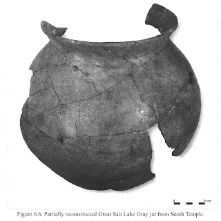
Partially reconstructed Great Salt Lake Gray ceramic jar.
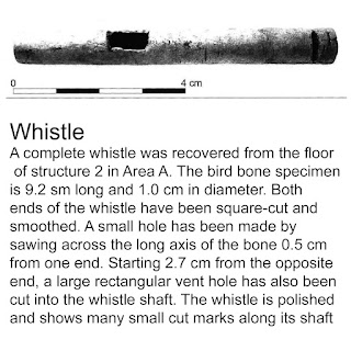
A bone whistle.

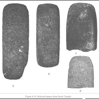
Selected two-handed manos.
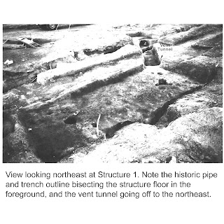
Archaeological excavation of Structure 1.
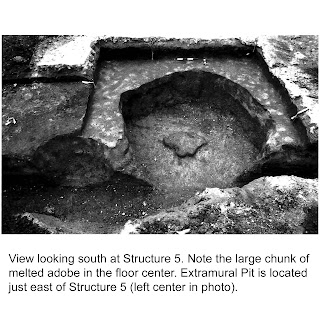
Archaeological excavation of Structure 5, note melted adobe in middle.
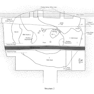
Plan view of Structure 2.


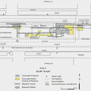
Archaeological plan view excavated area of Area A on South Temple.

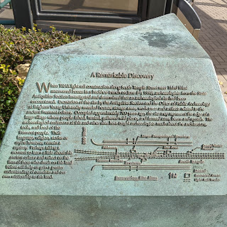
Interpretive plaque located at the Arena TRAX station showing excavated area, 2021.

23 October 2021

The Witch's House in City Creek Canyon... Is Really the Empire Mill

SLC urban legends tell of the “Witch’s Cabin” (or house or hut) located in City Creek Natural Area above Memory Grove Park (about where 11th Ave would cross City Creek).

Foundation of the Sudbury House (and later Bandstand),
part of the Empire Mill complex, Oct 2021.
 
The tales vary but usually include disembodied lights and voices. Sometimes it is a bad witch, sometimes a good witch, and sometimes the witch turns into a tree. Often the stories get muddled with other tales of Memory Grove.

The actual history is that this stone foundation is the remnants of the Empire Grist Mill complex, specifically the house of Samuel J. Sudbury, the miller employed by Brigham Young.

The Empire Mill was constructed in 1862 by mill architect Frederick Kesler for Brigham Young. Kesler also designed the Chase Mill which was similar in design. Samuel J. Sudbury operated the mill for 17 years for Brigham Young.

The mill’s primary business was to convert tithing wheat (10% of a Mormon farmer’s grain harvest) into flour which was then sold at the Tithing Store on South Temple and Main Street.

The mill was 3 stories tall with a stone foundation and wood frame superstructure. A massive 30 ft diameter waterwheel powered the machinery which produced 100 sacks of flour a day with its 2 pairs of French Burr grinding stones. The adjacent house was occupied by the Sudbury family and had a large garden and orchard.

On May 22, 1883, the mill burned to the ground destroying the mill and $8K of wheat and flour (~$217K today). The equipment that could be salvaged, including the millstones, were relocated to the Chase Mill, which is now in Liberty Park.

In 1902 Salt Lake City purchased the upper part of City Creek Canyon from the family of Brigham Young, which included the ruins of the Empire Mill and Sudbury House. In 1913, the SLC chain gang demolished the remaining walls of the mill complex.

In 1914 the SLC Parks Department built a new bandstand on the foundation of the old house as part of the grand opening of the new City Creek Boulevard (now North Canyon Road) and the construction of a footpath up the canyon (now the Freedom Trail).

The building of the bandstand explains the current configuration of the ruins: the concrete capped walls and stairs, the stone pillars along the walls, steel posts within the pillars, and entrances on all 4 sides of the foundation.

Throughout the 1920s the ruins of the old mill, by then mostly known as Sudbury’s Mill or Sudbury’s Flat, was a popular spot for picnics.

From what I could determine, by the 1970s memory of the old Empire Mill and house had been mostly forgotten and the urban legends of hauntings became more prevalent.

In fact, in a Facebook post on Utah’s Haunted History, Meretta England says that in 1976 she and her friends haunted Memory Grove as a prank and are responsible for the Ghost Bride stories.

NOTE 1:
If you are interested in the paranormal aspect of this area I found that The Ghost Box podcast Episode 2 “Memory Grove Never Forgets” was a good balance between the skeptic and the believer. 

NOTE 2:
The ruins of the old Empire Mill are located on land owned and administered by Salt Lake City and is within the City Creek National Historic District and the local City Creek Local Historic District. This means that the Salt Lake City government (and the SLC Historic Landmarks Commission) is responsible for the oversight, preservation, and interpretation of this site.


Sources:
Deseret News 1883-05-23; Salt Lake Tribune 1891-07-19; Salt Lake Herald 1913-07-27; Deseret News 1914-04-29; Salt Lake Tribune 1920-04-30; Salt Lake Tribune 1921-06-12; Salt Lake Tribune 1925-05-10; UDSH Liberty Park site file; SLC Plat D; Utah’s Haunted History Memory Grove thread 2020-05-17.

Foundation of the Sudbury House (and later Bandstand),
part of the Empire Mill complex, Oct 2021.

Foundation of the Sudbury House (and later Bandstand),
part of the Empire Mill complex, Oct 2021.

Detail of foundation walls. Note the concrete cap and steel pipe post. 

Composite image of Empire Mill photograph and SLC Plat D Map, both from UDSH

Colorized photo of Empire Mill with labeled notes.
Composite image of Empire Mill plans, from UDSH.

07 October 2021

Salt Lake City's Gravity Hill

Gravity Hill, City Creek Canyon.
Looking "up" but downstream. 2021.
City Creek Canyon abounds with urban legends of hauntings and mysterious phenomena, one of these places of mystery is Gravity Hill.

Gravity Hill is a stretch of road on Bonneville Blvd in City Creek Canyon where it appears that things, including cars, defy gravity and roll uphill. This is an optical illusion caused by an obscured view of the horizon. Gravity Hills are actually quite common and have been documented all over the world.

Some of the many stories involving SLC’s Gravity Hill involve a woman in a white dress haunting the canyon, magnets in the state capitol pulling cars upward, and a ghost of a farmer who was killed when his tractor overturned. 

The story of Gravity Hill begins with the creation of Bonneville Blvd, which today forms a loop within the City Creek Natural Area. It can be accessed by vehicle from B Street and 11th Ave and exited on the northeast side of the State Capitol building. It was proposed in 1913 and by the 1920s the loop that we know today had been cut into the hillside and was a decent dirt road popular with motorists. The road was widened and improved in 1938.

There is no evidence that Gravity Hill was a defined location of interest during the 1920s or 1930s. My hypothesis is that the lack of trees during this time did not obscure the horizon along the roadway preventing the optical illusion.

By the 1940s the phenomenon at Gravity Hill was well-known by local Salt Lakers but it really seemed to gain popularity in the 1960s and 1970s, especially among teenagers seeking thrills and secluded spots for romantic encounters.

The flood of 1983 caused extensive damage to City Creek Canyon and after repairs and stabilization efforts were completed Bonneville Blvd was made into a one-way street for vehicles. As such, it is no longer possible to drive the south/downstream to experience the optical illusion. But cyclists and hikers can still enjoy it, simply travel downstream along the east side of Bonneville Blvd near the intersection with North Canyon Road.

Sources:
SL Herald 1916-01-06; Des News 1938-04-15; SL Trib 1945-07-17; SL Trib 1965-08-23; Des News 1991-02-18

Bonneville Blvd, 1970s. From UDSH.

A tire rolling “uphill” 1965. From SL Trib 1965-08-23

Oldsmobile at 11th Ave & B St, 1919. From UDSH.

Map showing SLC's Gravity Hill. From Google Maps.