Showing posts with label Ballpark Neighborhood. Show all posts

24 September 2024

Artist Ralphael Plescia's Christian School at 1324 S State SLC is nearing demolition

Artist Ralphael Plescia's Christian School at 1324 S State SLC is nearing demolition.

You may have seen the news report that many of his sculptures were removed recently and will be rehomed to the Utah Arts Alliance's Art Castle (the old 15th Ward LDS Church building they purchased and saved from demolition in 2021).

I toured the interior of the Christian School in 2023. Here are some of those images.

The space is divided into 3 levels, which I interpreted roughly as akin to heaven (top), the terrestrial world (main floor), and the underworld (basement, sub-basement dug-out).


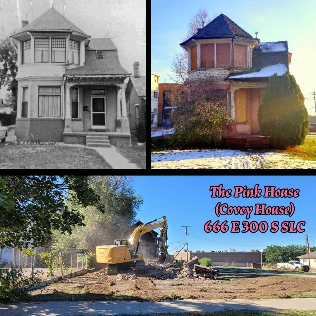
My understanding is that the building will be demolished and new apartments will be constructed.

The ownership of the building is a complicated relationship. Ralphael Plescia did not own the building, rather his father owned the building, and in his father's will he arranged for Ralphael to have occupant rights until Ralphael's death. After Ralphael's death in 2022, the ownership of the building went to Shriners Children's Hospital, per his father's will.

The Salt Lake Tribune reported on Aug 4 2023 that developer Colmena Group (via a LLC named 1324 South State, LLC). purchased the property from Shriners, although Ralphael's daughter had attempted to gain ownership.

Many of Plescia's sculptures cannot be removed from the building because they are a part of the building.

13 July 2024

SLC’s redlining map from the 1930s

A redline map of Salt Lake City from the 1930s. Another interesting and important map.

Federal Home Loan Bank Board. Home Owners' Loan Corporation. 1933-7/1/1939.
F
rom the National Archives.

Clip of the map legend. From the National Archives.

During the Great Depression, the Federal Home Loan Bank Board created residential security maps to indicate the risk of default on federally-backed mortgages.

Demographic information, such as race, was used to create these maps.

Green and blue neighborhoods were considered less risky areas to issue a mortgage and usually had majority-White populations. They were described as “best” and “still desirable” neighborhoods.

Often these neighborhoods had restrictive covenants that prohibited people of color from living in the neighborhood. The Westmoreland neighborhood of SLC is an example of this.

Yellow neighborhoods were designated as “definitely declining” and seen as places where “undesirable populations” may increase.

Red neighborhoods were “hazardous” and were associated with higher populations of people of color. Red neighborhoods were ineligible for federally backed mortgages making it difficult for residents in the neighborhood to become homeowners.

Thus, the term “redlining” refers to those red or “hazardous” neighborhoods that tended to have a higher percentage of residents that were people of color.

These maps recorded the existing conditions of the 1930s and then they were used to reinforce and perpetuate segregated neighborhoods.

This map is from the National Archives, direct link: https://catalog.archives.gov/id/85713738

I geo-referenced the redlining map and overlayed modern neighborhood boundaries using GIS. Even today, much of today's neighborhood boundaries align with the redlining map.

The 1930s SLC Redlining Map, with modern Community Council districts, overlayed. 

Detail clip of SLC's Redlining Map, showing Avenues, Downtown, Central City, East Central, University, and Liberty Wells neighborhoods.

Detail clip of SLC's Redlining Map, showing Rose Park, Fairpark, and Capitol Hill neighborhoods.

Detail clip of SLC's Redlining Map, showing Poplar Grove and Glendale neighborhoods.

Detail clip of SLC's Redlining Map, showing East Central, Wasatch Hollow, and Sugar House neighborhoods.  Note that the old State Prison (Sugar House Park site) is identified as "Yellow."

Detail clip of SLC's Redlining Map, showing Yalecrest, Foothill/Sunyside, and Wasatch Hollow neighborhoods.

04 January 2024

2023 Recap with Demolished Salt Lake Podcast

I was a guest on episodes 31 and 32 of the Demolished Salt Lake Podcast. “2023 Preservation Wins, Loses and What to Watch in 2024.”

We discussed some of the buildings we lost in 2023, the ones that were saved, and those that are in danger of demolition in 2024. We had more saves than losses this year, which was greatly needed after the past few years.

In this first of two parts, we talk about the loss of the Pink House and the Yardstick Building earlier this year. Discuss the status of the land on which some historic buildings used to stand in my “Still a Parking Lot” segment (ahem... the La France Apartments) and move on to buildings that will be demolished in 2024. Saving the best for last, we end with good news for a few of our historic buildings and areas.

We know we missed some buildings, but these are some of the standouts.

With – Wendi Pettett and Chris Jensen of Demolished Salt Lake Podcast and Adrienne White of House Genealogy

Photos of some of the highlights:

1. The Pink House (Covey House), 666 E 300 South SLC
2. Mountain Bell Building, 205 E 200 South SLC
3. Elias Harrison House, 10 N 300 West SLC
4. Cramer House, 241 Floral St SLC
5. Liberty Wells Center, 707 S 400 East SLC
6. Musser House, 2157 S Lincoln St SLC
7. 2nd Ward Assembly Hall, 483 E 700 South SLC
8. Jerald and Sandra Tanner House / Utah Lighthouse Ministries, 1350-1358 S West Temple SLC
9. Brinton House, 4880 S Highland Circle Holladay
10. Wells Ward Chapel, 1990 S 500 East SLC


07 December 2022

Virtual tour of the Tanner House, 1350 S West Temple Salt Lake City

Virtual tour of the Tanner House, 1350 S West Temple SLC, by RealScape Media

RealScape recorded this tour to preserve what they could, as demolition is proposed for this Ballpark gem. Check out that woodwork! 

Here is the link to the full tour.

Tanner House in Ballpark Neighborhood, Salt Lake City

(Reposted from PreservationUtah's Instagram)

Over the past several weeks, many have been very sad to learn that two historic houses in Salt Lake City's Ballpark Neighborhood will likely be demolished in short order and replaced with a condo or apartment building. These houses, 1350 and 1358 South West Temple, both built around 1900, have lent the Ballpark Neighborhood a great deal of character over the past 120 or more years.

1350 is our favorite of these two houses as it has some really wonderful architectural features. It is rare to find houses in Salt Lake that boast gables as ornamented as those found on this house. Imagine the skill required to piece these gables together!

Many know that 1350 served as a home and headquarters for Jerald and Sandra Tanner of Utah Lighthouse Ministries. We tried to uncover the earlier chapters of 1350's history.

The first bit of information we could find on 1350 dated to 1917, when three of its rooms, "newly painted and papered, partly modern" came up for $8 / month rent. The next year, the whole house could be rented for $16/month rent.

By 1922, 1350 S. West Temple sheltered Thomas S. and Olive Van Cott Davis who remained in this house for many years. It is easy to fall in love with the Davis family via records of their comings and goings in local newspapers. While at 1350, the Davis's celebrated the weddings of their children, held DUP camp meetings, showers, and a large variety of other community gatherings. The Davis's stay at 1350 was also filled with tragedy. While living in this house, the family suffered automobile accidents, sicknesses, deaths, and other of life's vicissitudes.

By 1967, 1350 S. West Temple housed Modern Microfilm, the forerunner to the Utah Lighthouse Ministry.

It is no exaggeration to say that a great deal of life has played out at 1350 S. West Temple.

In the very near future, Preservation Utah looks forward to working with the Ballpark Community Council and other invested parties to introduce more of this neighborhood to the National Register of Historic Places and other preservation-centered initiatives. Hopefully, these efforts will help to preserve more of Ballpark's treasures.

06 December 2021

Update on the Ghost Sign at 1480 S State

The old Pappy's Pawn at 1480 S State as it is today, Dec 6 2021.

An update on the old ghost sign uncovered at the now-closed Pappy’s Pawn at 1480 SState, Salt Lake City.:

As of this morning (6 Dec 2021), the stucco has been repaired and painted red, meaning that the recently uncovered sign is now hidden again behind the stucco (see the previous post).

 
The old Pappy's Pawn at 1480 S State as it is today, Dec 6 2021.
Note the lack of seagull statues on top of the pawn sign.

Also note that the existing sign no longer has the seagulls, which we learned from @handysixdeuce that the seagulls were originally part of a massive art installation at the now-demolished Prudential Federal Savings building previously located at 115 S Main Street SLC and is now the site of the Eccles Theater. 

I'm not sure if Pappy took the seagulls with him or if the new owners have them. I just hope they didn't end up in the trash.

Here are some interesting articles about the art and architecture of the Prudential Building, the 2014 demolition of the building, and the promise of SLC to reincorporate the seagulls into the Eccles Theater - which has not happened.


Of note, the Prudential Building was designed by architect William Pereira who is best known for designing San Francisco's iconic Transamerica Pyramid.

The seagull piece was named "The Gulls of Salt Lake City" and was created by California artist Tom Van Sant with the aid of master welder Timothy E. Smith. It consisted of 100 gulls attached to three stainless steel rods, 120 feet long, held in tension between the roof and a sunken garden below street level. A cricket was placed at the top of the sculpture.
Prudential building and seagull sculpture in the 1960s.
From Utah Division of State History site file.


Prudential building and seagull sculpture in the 1960s.
From Utah Division of State History site file.


05 December 2021

Ghost Sign on State Street, Dec 2021

The other day I saw this historic painted sign being uncovered by workers at 1480 S State Street Salt Lake City, which is the recently closed Pappy’s Pawn shop. Pappy was of Greek heritage and a longtime resident of State Street. 

Detail of newly revealed painted sign, Dec 2021.

The workers said they were repairing the stucco when they found this older sign under it. The workers thought the older sign was incredibly cool and were carefully working to keep it intact.

Unfortunately, it will not be visible for long as the plans of the new owner are to cover it back up.

I did a little history digging and found that the building was constructed in 1938.

Below is an incomplete list of businesses that have occupied the space:
  • Crystal Laundry (1930s-1940s)
  • Good Laundry and Dry Cleaning (1940s-1960s)
  • European Auto Parts Inc (1960s-1970s)
  • Jensen Distributing Co (1970s)
  • Betty’s Collectables (1975-1976)
  • Earl Shiel (1980s)
  • Pappy’s Pawn (1990s-2020s)
The only letters clearly uncovered are “ING” so I’m not sure what the full word could be but my best guess is Good Laundry and Dry Cleaning which was operated by a Japanese-American family.

View of Pappys Pawn as it appeared in 2019, from Google Street View.