Showing posts with label 1930s. Show all posts

16 April 2025

Crystal Palace Market Ghost Sign

The Crystal Palace Market ghost sign appeared briefly at 240 S 1300 E SLC.  I took this photo last night (4/15/2025) and by tonight (4/16/2025) it was covered with plywood.

The Crystal Palace Market ghost sign at 240 South 1300 East Salt Lake City

The building was constructed in 1935 and opened as Sewells United Stores, a grocery chain originating in Nevada and operating in the intermountain west.

The Crystal Palace markets were a competing chain in SLC.

In 1937 Sewells acquired 3 Crystal Palace markets and, along with their 2 other SLC Sewell stores (including this one), merged them under the name Sewells Crystal Palace.

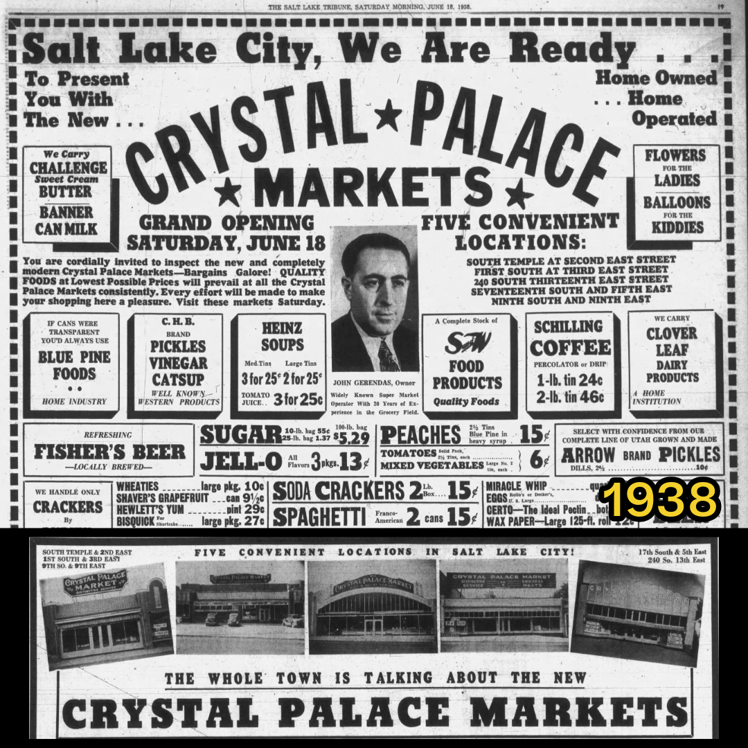
In May 1938, Sewells sold their 5 SLC stores to John Gerendas, a Greek immigrant who had co-established the Success Markets in Helper, Utah.

Gerendas changed the names of all 5 markets to Crystal Palace, with locations at:

• No. 1: 525 E 1700 South
• No. 2: 304 E 100 South
• No. 3: 216 E South Temple
• No. 4: 914 E 900 South
• No. 5: 240 S 1300 East

This location near the University of Utah at 240 S 1300 East was Crystal Palace Market No 5.

Gerendas expanded and eventually owned 9 Crystal Palace markets.

Gerendas became ill and died in 1942. Before his death, he sold most of his stores to his employees. His son, Greg, continued operations of some of the Crystal Palace markets.

Gerendas helped employees Bill Ward and Harold Robinson purchase this location. They put a Robinson & Ward sign in the window but kept the big Crystal Palace sign on the building.

The market served the University of Utah area until 1988. It was the longest serving and last Crystal Palace market to close.

The building was converted into a restaurant space and opened as Pancho Villa U in 1989. It changed hands several times in the 1990s including Hot Rod Hundley’s Sports Family Restaurant, China Star, and Einstein Bros Bagels. It was most recently Coffee & Tonic.

SLC building permit plans indicate the new space will be a restaurant (named Henry Baker?). The renovation project includes an interior remodel, restoration of existing brick, facade renovation, window replacement, addition of a front canopy, small rear addition with steel stairs, and changes to entry walls and landscaping.


31 March 2025

New GE Refrigerators at the Critchlow Apts

This is a fun photo of the Critchlow Apartments at 379 1st Ave SLC (now known as First Avenue Flats).

General Electric Refrigerators for installation at Critchlow Apartments, Salt Lake City. ca 1929.
Image from USHS.

Detail of above.

It shows the delivery of new General Electric refrigerators, probably in 1929.

Known as “Monitor Top” refrigerators because their top mounted compressors resembled the gun turret of the Civil War ship, USS Monitor.

GE Monitor-Top Refrigerator.
Image from Albany Institute of Art History and Art

These were considered the first affordable refrigeration units for the average family, around $300 (about $5,500 in 2025 dollars). Often these refrigerators, and other electric devices, were offered for sale through the electric utility company, in this case, Utah Power and Light.


09 February 2025

Salt Lake's Franklin Avenue as a Historic Black Neighborhood

General location of Franklin Avenue, between 200-300 South and State St-200 East

Between about 1885 and the 1920s, Franklin Ave (now Edison St) became home to a large population of Black Americans.

This mid-block alley situated within the original 13th Ward, started out like other blocks of the original SLC plat- residential and agricultural lands divided among early Mormon settlers of the 1840s-1850s.

After the completion of the transcontinental railroad in 1869 (through Ogden) and the first railroad spur to SLC in 1870, new arrivals became more common. Coupled with the great western migration of Black Americans after the Civil War, Salt Lake (and Ogden) became a place for people to find work relating to the railroad and hospitality, often the only type of jobs that Black people were allowed to obtain, such as porters, waiters, cooks, maids, laborers, etc. As such, both Salt Lake and Ogden saw population increase of Black Americans and other groups.

A view of Salt Lake City in the 1870s. Although Franklin Ave is located outside the image, it gives a good idea of what the area looked like at this time.
 
Also, by 1870, those early log cabins and small adobe homes on large parcels belonging to the original Mormon settlers had largely fallen into disrepair and had been subdivided; sometimes sold for redevelopment and sometimes rented out to the new SLC arrivals, generally those economically disadvantaged newcomers who could afford these low-cost rentals. On Franklin Avenue, these tended to be Scandinavian speaking converts to the LDS church (through the 1870s-1880s) and eventually to Black Americans.

Franklin Ave had a reputation for being a tough neighborhood in the 1870s. At the time a large Scandinavian population lived on the street. As was common with mid-block alleys, a number of raucous characters were present. Newspapers noted that two families often indulged “in the unlawful practice of calling each other bad names, in the Scandinavian language.”

Brothels started up on Franklin Ave at this time as well. Mid-block alleys and the hidden center of city blocks were out of sight from the more respectable business along the main streets and thus became the preferred location of many vices. At this time the brothels on Franklin Ave seem to have only been run by White people, mostly women. By 1878 the Deseret News identified Franklin Ave as a “Bad Place” with “loose characters.”

The 1880s brought some Black people to the neighborhood. The first Black residents of Franklin Ave that I could find were Alice and Benjamin Nesbitt who resided there in 1884. Alice later became president of the Colored women’s Republican Club and worked to secure voting rights for Black women in Utah. The rooms and houses available for rent were owned primarily by White people; the most prominent owner being John Johnson who supplied rented housing and jobs to people on Franklin Ave.

Notably, many of the buildings were lacking in maintenance and sanitary conditions were atrocious. A sewer line was installed in 1888 but many of the older homes were never connected, and outhouses remained common. The street remained unpaved through this time, which is an important consideration of the sanitary conditions when coupled with lack of standardized garbage disposal, accumulation of animal waste, and the prevalence of coal burning stoves.

Franklin Ave in 1905. One of the earlier images showing the majority residential buildings.

By the time the first Black residents moved into Franklin Ave in the mid-1880s, the street was already a difficult neighborhood. Rents were probably cheap, but brothels and gambling dens were common.

Sanitary conditions were notably inadequate. The Salt Lake Herald complained for several years of the perpetual cesspool that existed on the southern end of Franklin Ave at 300 South; their 1888 article described it as a “slimy, green, stagnant pool [that] emits a very nauseating effluvia these warm days and is bound to make somebody sick…”

The 1890s saw a dramatic shift from White to Black residents, likely drawn by cheap rent. Some of this influx was due to the arrival of the 24th Infantry (Buffalo Soldiers) at Fort Douglas in 1896 with some of the Soldiers families living on Franklin Ave and some Soldiers choosing to stay in SLC after they were discharged from the Army.

The 1900 census shows all but one of the buildings on Franklin Ave were home to Black families, including Ella Phelps who, along with her husband James and son James Roscoe, ran a rooming house for other Black individuals at 249 Franklin Ave (now a parking lot). Notably the Phelps did not own their building.

The exception to Black residents was the Salvation Army’s Workingmen’s Hotel (which is now the Franklin Ave Theater building at 231 Edison- more on that later) which was occupied only by White men.

The Black population of SLC continued to increase, especially in and around Franklin Ave. Throughout the 1890s and early 1900s the Salt Lake Herald-Republican newspaper referred to the street as “Darktown.”

Many of the SLC Black organizations that exist today can trace their beginnings to the residents of Franklin Ave. Both Calvary Baptist Church and Trinity African Methodist Episcopal (AME) Church began on Franklin Ave with the initial fundraising efforts and early church meetings.

In 1906, SLC changed the name of Franklin Ave to Edison St, largely to “rebrand” the street from Black residential to White commercial. The first White-owned business, Skelton Printing, moved into the Franklin Ave Theater building in 1906.

Throughout the next decade more business displaced the residents. The 1911 Sanborn Map indicates about half of the buildings on Franklin Ave/Edison St were residential, mostly on the southern half of the street. By 1926, the Sanborn Map shows no residential buildings.

Many of the displaced residents moved to the south end of the Central City neighborhood, mostly 400 South-900 South and Main St-500 East.

Edison Street (formerly Franklin Ave) in 1936, showing majority commercial buildings.


A note on Salt Lake's Black population:

In 1900, 278 Black people were recorded as living in SLC and in 1910 this increased to 737, most of whom (but not all) lived on or around Franklin Ave. The overall Black population in SLC was small during this time, only about 1% of SLC (even accounting for undercounting of the census).
  • 1900: 278 black / 77,725 total SLC population = 0.4%
  • 1910 737 black / 131,462 total SLC population = 0.6%
For comparison, the 2020 census records Utah's Black population as 2%


Sanborn Maps showing the transition of Franklin Ave to Edison Street, 1926-1950


Blue Houses = Residential Buildings
Red Shopping Cart = Commercial Buildings


.

05 December 2024

Then and Now: The Rio Grande Depot

Then and Now: The Rio Grande Depot at 300 S. Rio Grande St, Salt Lake City.  

Then is ca. 1920-1930. It is a historic photo of the Rio Grande Depot from the Denver Public Library Special Collections (Number GB-5633). Now is from 2018 Google Streets View.

At the time of the photo, the building was known as The Denver and Rio Grande Railroad Depot.

Note the trolly tracks in the foreground. Passengers disembarking from the Depot could then access Salt Lake’s large network of trolley lines in all directions.


25 October 2024

The Old Mill in Cottonwood Heights is often reported as haunted

The Old Mill, aka Granite Paper Mill, at the mouth of Big Cottonwood Canyon

The Old Mill in Cottonwood Heights is often reported as haunted. People report shadowy figures, cold spots, odd lights, sounds of footprints, and voices. Several stories involve people and dogs who have died in fires, suicides, and curses.

These spooky stories are difficult to tie directly to its history. Located at the mouth of Big Cottonwood Canyon, it was built in 1883 by the Deseret News to make paper for the newspaper.

The 3-story structure is built of granite from the same quarry as the Salt Lake City LDS Temple. It contains a basement and a prominent 100-foot elevator tower.

At the time of its operation, the main floor housed a machine room, engine room, rotary boiler, and cutting room. The upper story of the building was used for sorting material (mostly straw and rags) and the basement contained drainers and agitators. Power to the mill came from water forced into three separate power wheels through a 50-inch floodgate.

Image from USHS
 
Image from USHS.

A massive fire broke out in 1893 and gutted the entire building causing major damage to the roof structure and the papermaking machinery. A stockpile of paper also went up in flames. Insurance only covered a fraction of the loss, which, combined with the economical efficiencies of wood-pulp paper industry resulted in the abandonment of the mill.

In 1927, it was converted to a resort clubhouse; a portion of the building was repaired with a new roof and the south wing remaining uncovered. The Old Mill Club was originally advertised as a prestigious destination with horseback riding through Big Cottonwood Canyon, nightly dancing (except Sunday), trapshooting at its gun club, and plans for an 18-hole golf course to be designed by famed golf course architect, William H. Tucker. Other future plans included banquet and dining rooms to be run by a chef of “interesting fame,” swimming pool, and a toboggan slide.

As an aside – some of the names given to the 18 horses of the riding club are reminiscent of the roaring 20s.
      • Smokey
      • Kernal
      • Buster
      • Sox
      • Moonshine
      • Budweiser
      • Blaze
      • Snip
      • Red Bird
      • Dan Patch
      • Shorty
      • Smiler
      • King Tut
      • Zane Grey
      • Queen Ann
      • Cleopatra
      • White Cloud
      • Arabian
The Old Mill Club was intended to rival Salt Lake City’s Country Club and provide restful relaxation and complete privacy to its members. It also hosted theme events such as “Chocolate Night” and “Tabernacle Choir Night” and “Halloween Night.”

The Old Mill, ca 1930, when it was a dance hall, Big Cottonwood Canyon. Image from USHS.
 
Dancing at the Old Mill. Image from USHS.
 
Advertisements from the Old Mill Club
Left: The Salt Lake Tribune 1930-10-27 p11
Right: The Bingham Bulletin 1927-08-04 p5
 
Interior of the Old Mill, 1967. From HABS No U-39, NPS.
 
John Basil Walker operated the Old Mill Club from 1927 to 1942. He also owned Walker Sand and Gravel which operated the gravel pit adjacent to the Old Mill at 6950 Wasatch Boulevard.

The Old Mill Club closed during WWII, but the property remained in the Walker family for several more decades. The building had many phases of being empty and being used as an entertainment venue, including being utilized as a haunted house in the 1970s-1990s. The building was condemned by Cottonwood Heights City in 2005.

It has also appeared in several movies including “SLC Punk,” “Team Alien/The Varrow Mission,” “Halloween: The Curse of Michael Meyers,” “Hereditary,” “Bleep” and “March of Dimes.”

I have included some scenes from "Team Alien/The Varrow Mission", which can be viewed on YouTube.
 
Scenes from "Team Alien/The Varrow Mission"

The Old Mill in 2012

Sources:
  • Granite Paper Mill HABS No U-39, National Park Service
  • Davis County Clipper 1893-04-06
  • Deseret News 1884-10-15 p7
  • Deseret News 1893-04-01 p2
  • Salt Lake Tribune 1927-07-21 p9
  • The Bingham Bulletin 1927-09-15 p5
  • The Bingham Bulletin 1927-11-23 p7
  • Salt Lake Tribune 1927-09-23 p9
  • Salt Lake Tribune 1927-08-26 p17
  • Deseret News 1927-12-09 p14
  • Salt Lake Tribune 1973-10-28 p66
  • A Directory of the Mining Industry of Utah 1965. University of Utah Bulletin 79

30 September 2024

Midwest Casket Company Building at 440 W 600 South SLC

Midwest Casket Co Building, September 2024.
Note the recently demolished buildings to the east (right). 

Midwest Casket Co Building, September 2024.

The old Midwest Casket Company building at 440 W 600 South is one that you have likely passed by on numerous occasions. It is representative of the transition to modern funeral services, especially among the middle class.

The building was constructed in 1912 (although the Salt Lake County Assessor states 1905) for the Utah Casket Company for the manufacture of caskets, undertaker’s supplies, and a dressmaking department for burial dresses, shrouds, and robes.

The early 1900s was a busy time for the casket industry in SLC. Prior to about 1880, SLC had one primary undertaker – Joseph Edward Taylor (often referred to as the Pioneer Undertaker) and his family. He was appointed by Brigham Young to be the SLC Cemetery Sextant, undertaker, and provide coffins (through his father-in-law, William Capener, who was a cabinet maker).

Slowly, things changed around 1880. In James Farrell’s book “Inventing the American Way of Death 1830-1920” (so interesting!), he indicates the growth of the middle class demanded attention to the deceased “more in accordance with their surroundings,” meaning something more elaborate than a simple box lined with linen. At this same time in SLC, a greater influx of non-Mormons demanded a greater variety of services, commodities, and cemeteries.

Utah Casket Company advertisement showing an elaborate casket, 1913.
Clip from Salt Lake Herald 1913-04-04 Page14
 
At the end of the 1800s, there were a variety of funerary start-up businesses. Most only lasted a few years but several have endured to the modern time (some names you may recognize Evans, O’Donnell, or Larkin). Often, when one of these businesses ended, another would purchase their real estate and equipment, often at auction.

This is what happened with the original occupant of this building; in 1910 a newly incorporated Utah Casket Company acquired the equipment of the Crescent Manufacturing Company. 

Crescent manufactured caskets and its establishment in SLC was a bit of weird situation. Through my reading of the old newspapers articles, it seems that Mr. Edward H. Sherman re-established Crescent Manufacturing Company in SLC in 1908 from Butte, Montana and it seems he did so in order to escape a significant judgement against the company in Butte. In 1910 Sherman sold the equipment and supplies of Crescent in exchange for stock in the Utah Casket Company. At the time, Utah Casket Company was located at 32-36 E 800 South.

A year later, in December 1911, The Utah Casket Company announced it would build a new modern facility to manufacture caskets, undertaker’s supplies, and couches at 440 W 600 South. The two-story building is constructed of brick and cement and was constructed so that a third story could be added if needed. The building was “modern in every detail…with rest and lunchrooms for the employees, which will include a large number of women” who worked in the sewing department creating burial clothing, shrouds, and linings for the caskets. The building formally opened in October 1912.

Utah Casket Factory announcement illustration, January 1912.
Clip from the The Salt Lake Tribune 1912-01-28 Page 11

Utah Casket Company building completion, December 1912
Clip from the Deseret News 1912-12-21 Page 97
 
Two workplace accidents at 440 W 600 South were reported in the newspapers in January 1919. Sixteen year old Rulon Hanson lost his little finger of his left hand while working with the buzz saw and another employee lost four fingers of his right hand while using the same saw.

The Utah Casket Company occupied the building for about 8 years. They exhibited their caskets at the Utah State Fair and won a blue ribbon, which they proudly advertised. Around 1920, Utah Casket Company was defunct.

Around the same time period, there were competing casket business. The Salt Lake Casket Company was incorporated in 1910; this company was associated with Joseph E. Taylor (“Pioneer Undertaker”) and his son Alma O. Taylor and was the successor and outgrowth of Joseph E. Taylor’s operation. 

In 1919, Alma O. Taylor split from Salt Lake Casket Company (run by his brothers Samuel and Joseph Taylor) to form the Intermountain Casket company with Lafayette Holbrook. In 1920 the Intermountain Casket Company opened a new three-story building at 276 W 100 South and is still standing in SLC’s Japantown.

In 1920, it was the Salt Lake Casket Company that acquired the building at 440 W 600 South including the real estate, building, and equipment of the defunct Utah Casket Company. They occupied the building for several years. In 1937 the company was bankrupt and the building, real estate, machinery, fixtures, and equipment were sold at public auction.

Around 1938 the Midwest Casket Company moved into the building. Midwest Casket was associated with brothers Curt and Henry Skola. Midwest Casket occupied the building for decades. It became known for its custom caskets and interiors, including caskets for pets. They provided custom options in an ever-growing market of mass production with limited choices.

A 1991 article from the Salt Lake Tribune interviewed three women who worked as seamstresses at Midwest Casket. They worked in a sunny room on the top floor that was filled with bolts of fabric and antique sewing machines. (The casket production area was on the main floor.)

As an example of how the workplace environment has changed since 1991, there were posters of Chippendale dancers in thong bathing suites covering holes in the walls on one side of the room. In 1968 they provided 35 caskets for an airplane crash at the SLC Airport. They provided caskets for LDS church presidents, local politicians and in 1985 they sent a champagne velvet lined casket for actor Rock Hudson as one of the options for his burial. They are still in business and have relocated to South Salt Lake.

Recently the building and surrounding parcels are undergoing redevelopment as part of the Silos Block project in the Granary District. Many buildings on the block have been or will be demolished, the most notable being the Cereal Foods Silos.

The Midwest Casket building is to be preserved and adaptively reused as a commercial space. The adjacent building to the west (Euro Treasures) will also be preserved and adaptively reused (plans indicate a garage for 117 parking stalls). Rimini Coffee at 532 S 400 West will also remain.

Also of note, the old Portland Cement art-dec style building (554 S 400 West) will be demolished.


Sources
  • Sanborn Maps for Salt Lake City, 1898,1911,1926,1950,1969
  • Salt Lake Herald Sat, Sep 03, 1910 ·Page 15
  • Salt Lake Telegram Thu, Dec 08, 1910 ·Page 10
  • Salt Lake Herald Wed, Dec 13, 1911 ·Page 4
  • The Salt Lake Tribune Sun, Jan 28, 1912 ·Page 11
  • The Salt Lake Tribune Mon, Jul 08, 1912 ·Page 10
  • Salt Lake Herald Fri, Oct 04, 1912 ·Page 12
  • Deseret News Sat, Dec 21, 1912 ·Page 97
  • Deseret News Sat, Apr 05, 1913 ·Page 38
  • Salt Lake Herald Fri, Apr 04, 1913 ·Page 14
  • Salt Lake Herald Tue, Nov 16, 1915 ·Page 8
  • Salt Lake Telegram Fri, Jan 31, 1919 ·Page 13
  • Salt Lake Tribune Oct 7 1919 Page 20
  • Deseret News 1930-10-26 Page 32
  • The Salt Lake Tribune Thu, Dec 31, 1936 ·Page 20
  • Salt Lake Telegram Jan 6 1939 Page 16
  • Deseret News 1939/05/17 Page 11
  • The Salt Lake Tribune 1955-06-24 Page 54
  • The Salt Lake Tribune 1980-07-17 Page 103
  • The Salt Lake Tribune 1988-03-27 Page 41
  • The Salt Lake Tribune 1991-03-11 Page 12
  • The Salt Lake Tribune 1943-03-05
  • Biennial Report by Utah Secretary of State 1913
  • Kate B. Carter, Heart Throbs of the West, 1945, Daughters of the Utah Pioneers. 
  • James J. Farrell, Inventing the American Way of Death, 1830-1920. 1980. 
  • USHS Files for Midwestern Casket Co Building
  • USHS Files for Intermountain Casket Co Building
  • Salt Lake City, Silo Phase 2 Staff Report - Final, 2023

25 September 2024

The 5 statues atop the SLC City and County Building

The statue "Columbia" atop the SLC City and County Building, ca 1894.
Historic photo from USHS.

The five statues atop the SLC City and County Building (451 S State SLC) have an interesting past. The current statues were placed in 1986 and 1989 as part of the massive building restoration effort.

(Fun fact = the City and County building was the first in the nation to be retrofitted with a seismic base isolation system).

The five statues are:
  1. Columbia” is located atop the central clock tower. Columbia was the popular symbol of America before the Statue of Liberty
  2. Liberty” on the north gable
  3. Justice” on the south gable
  4. Commerce” on the east gable
  5. Commerce” on the west gable


    The SLC City and County Building in 1905. Note the presence of the statues.
    Historic photo from USHS.
The 5 statues were part of the original building, dedicated in 1894. They were made of pressed zinc and were painted to simulate the sandstone of the building. The original statues were ordered from a catalog at a cost of $325 for Columbia and $300 each for the others.

The catalog may have been the W. H. Mullins Catalogue of Architectural Ornaments and Statuary, which was one of the primary suppliers of zinc statues and located in Salem, Ohio. One of their catalogs can be viewed on archive.org.

The Mullins Company supplied a variety of statues and architectural ornaments to many public buildings at this time. In addition to the five discussed here, depictions of Agriculture, Science, Music, Industry, and Freedom were popular. Some of these original statues on public buildings throughout the US have been restored.

After a large 6.6 earthquake in 1934, Columbia, Liberty, and Justice were damaged and removed (“junked” according to a 1954 Deseret News article) from the City and County Building.

But the two Commerce statues remained until 1954, at which point severe corrosion was found with their iron mountings and they were also removed.

One of the Commerce statues was placed at the SLC Daughters of the Utah Pioneer Memorial Museum storeroom, where it remained until the 1980s (not sure where it is now).

The SLC City and County building was void of its statutes for decades, until the restoration effort of the late 1980s.

The SLC City and County Building in 1972. Note the lack of statues.
Historic photo from USHS.

The first statue to be restored was the centerpiece Columbia in 1986 by artist Richard Young. The first concept of Young was rejected as being “anorexic by 1890s standards.” Young’s second concept plumped up the goddess statue by adding bulk to the shoulders and hips to make it more closely resemble the original catalog model. The new Columbia is made of cast bronze and has a leaden-tin finish.

The Commerce statue on the east gable was also replaced in 1986 and was created by Gordon Lewis Newby and Rudy Chagney. It seems this statue replacement was part of a roofing contract.

The remaining three statues (Commerce on the west, Justice, and Liberty) were able to be replaced because the overall bid to renovate the building came in under budget. That allowed these three statues and some other work, like stone carving restoration, to be completed.

These remaining three statues (Justice, Liberty, and the western Commerce) were created by artist Angelo Caravaglia, whose work I have featured in past posts- the fountain in front of the Bennett Federal Building and the twin bronzes previously attached to the old Mountain Bell Data Center building.

The Justice, Liberty, and Commerce statues are all made of hammered copper sheet (repoussé technique) with a dark patina finish.


As the two Commerce statues were made by different people, they are significantly different in appearance. I have included a possible catalog image for comparison (although the items in the hands are opposite).

Sources:
  • Salt Lake Herald Republican 1893-12-08 p5
  • Deseret News 1954-06-17 p50
  • Daily Spectrum 1986-01-01- p4
  • Salt Lake Tribune 1986-08-10 p21
  • Daily Spectrum 1986-11-28 p2
  • Salt Lake Tribune 1987-02-05 p39
  • Salt Lake Tribune 1989-04-23 pg115
  • Salt Lake City Corporation Insurance Appraisal by Allen Dodworth Art Appraisal Associates. March 2013.
  • City and County Building SHPO file, Utah State Historical Society
  • Catalogue of architectural ornaments and statuary, in sheet zinc, brass or copper / manufactured by W.H. Mullins, Salem, Columbiana Co., Ohio. 1894 (from archive.org).
  • Zinc sculpture in America, 1850-1950 by Carol A Grisson, 2009. (from archive.org).  

13 July 2024

SLC’s redlining map from the 1930s

A redline map of Salt Lake City from the 1930s. Another interesting and important map.

Federal Home Loan Bank Board. Home Owners' Loan Corporation. 1933-7/1/1939.
F
rom the National Archives.

Clip of the map legend. From the National Archives.

During the Great Depression, the Federal Home Loan Bank Board created residential security maps to indicate the risk of default on federally-backed mortgages.

Demographic information, such as race, was used to create these maps.

Green and blue neighborhoods were considered less risky areas to issue a mortgage and usually had majority-White populations. They were described as “best” and “still desirable” neighborhoods.

Often these neighborhoods had restrictive covenants that prohibited people of color from living in the neighborhood. The Westmoreland neighborhood of SLC is an example of this.

Yellow neighborhoods were designated as “definitely declining” and seen as places where “undesirable populations” may increase.

Red neighborhoods were “hazardous” and were associated with higher populations of people of color. Red neighborhoods were ineligible for federally backed mortgages making it difficult for residents in the neighborhood to become homeowners.

Thus, the term “redlining” refers to those red or “hazardous” neighborhoods that tended to have a higher percentage of residents that were people of color.

These maps recorded the existing conditions of the 1930s and then they were used to reinforce and perpetuate segregated neighborhoods.

This map is from the National Archives, direct link: https://catalog.archives.gov/id/85713738

I geo-referenced the redlining map and overlayed modern neighborhood boundaries using GIS. Even today, much of today's neighborhood boundaries align with the redlining map.

The 1930s SLC Redlining Map, with modern Community Council districts, overlayed. 

Detail clip of SLC's Redlining Map, showing Avenues, Downtown, Central City, East Central, University, and Liberty Wells neighborhoods.

Detail clip of SLC's Redlining Map, showing Rose Park, Fairpark, and Capitol Hill neighborhoods.

Detail clip of SLC's Redlining Map, showing Poplar Grove and Glendale neighborhoods.

Detail clip of SLC's Redlining Map, showing East Central, Wasatch Hollow, and Sugar House neighborhoods.  Note that the old State Prison (Sugar House Park site) is identified as "Yellow."

Detail clip of SLC's Redlining Map, showing Yalecrest, Foothill/Sunyside, and Wasatch Hollow neighborhoods.