Showing posts with label West Side. Show all posts

05 December 2024

Then and Now: The Rio Grande Depot

Then and Now: The Rio Grande Depot at 300 S. Rio Grande St, Salt Lake City.  

Then is ca. 1920-1930. It is a historic photo of the Rio Grande Depot from the Denver Public Library Special Collections (Number GB-5633). Now is from 2018 Google Streets View.

At the time of the photo, the building was known as The Denver and Rio Grande Railroad Depot.

Note the trolly tracks in the foreground. Passengers disembarking from the Depot could then access Salt Lake’s large network of trolley lines in all directions.


27 November 2024

The old Diamond Lil's Steakhouse

Diamond Lil's, April 2005. Note "Home Maid"

An old photo of Diamond Lil's. A steakhouse at 1528 W. North Temple. It was destroyed by fire in 2021. I took this photo in 2015.

Here is a short history excerpted from a 2009 Intermountain Catholic article:

In November 1969, Jim Pietramali and Garth Campbell opened Diamond Lil’s doors for business at 1528 West North Temple. The original building was a modest home, which was remodeled using old barn lumber and logs from pioneer cabins, some of which are 100 to 150 years old.

The seating capacity was 32 people in about 1,000 square feet. Today [2009] the seating capacity is 500. The original kitchen was about the size of a large walk-in closet.

Today [2009] Diamond Lil’s is owned by Pete Funaro. He started working at Diamond Lil’s in 1970 for his uncle, Jim Pietramali. Pietramali, 87, still works for Diamond Lil’s.

“A lot of customers kept coming back and we became the premier steak house in Salt Lake City,” said Funaro. “We are an independent Utah’s own company. The seating allows for parties that can seat as many as 275 people at one time.

In 1973, they started adding on to Diamond Lil’s. They used only logs from Utah cabins.

Funaro also has his own wholesale pasta business, Funaro’s Perfect Pasta. Diamond Lil’s serves Funaro’s pasta. All of his pasta was used during the 2002 Winter Olympics in Salt Lake City.

13 August 2024

Demolition of the Glendale Neighborhood Tejada's Market Building, the old Safeway mid-century modern building

Tejada's Market building, August 2024.
1179 Navajo Street, Salt Lake City, Utah

The old Tejada’s Market building at 1179 Navajo Street in the Glendale neighborhood has a demolition permit filed with Salt Lake City and will likely soon be demolished. Townhomes are planned to be constructed in its place.

This building opened in February 1967 as a Safeway. It advertised a large parking lot to accommodate 138 cars and modern construction of “tilt-up stone walls, laminated roof beams, and expansive glass front.”

The building was designed by William J. Monroe & Associates of Salt Lake City and the construction contractor was Horne-Zwick Construction Co.

It was a Safeway through the mid-1980s, was briefly a Famer Jack market about 1987, and became a Food World in the 1990s. Most recently, the building has been home to Supermercardo de las Americas and the Tejada’s Market.

Source: Salt Lake Tribune 1967-02-12 p51

Tejada's Market building, originally a Safeway. August 2024.

Even the original light posts are still present, August 2024.

Tejada's Market building, originally a Safeway. August 2024.

Grand opening of the Glendale Safeway.
From the Salt Lake Tribune 1967-02-12 p51

13 July 2024

SLC’s redlining map from the 1930s

A redline map of Salt Lake City from the 1930s. Another interesting and important map.

Federal Home Loan Bank Board. Home Owners' Loan Corporation. 1933-7/1/1939.
F
rom the National Archives.

Clip of the map legend. From the National Archives.

During the Great Depression, the Federal Home Loan Bank Board created residential security maps to indicate the risk of default on federally-backed mortgages.

Demographic information, such as race, was used to create these maps.

Green and blue neighborhoods were considered less risky areas to issue a mortgage and usually had majority-White populations. They were described as “best” and “still desirable” neighborhoods.

Often these neighborhoods had restrictive covenants that prohibited people of color from living in the neighborhood. The Westmoreland neighborhood of SLC is an example of this.

Yellow neighborhoods were designated as “definitely declining” and seen as places where “undesirable populations” may increase.

Red neighborhoods were “hazardous” and were associated with higher populations of people of color. Red neighborhoods were ineligible for federally backed mortgages making it difficult for residents in the neighborhood to become homeowners.

Thus, the term “redlining” refers to those red or “hazardous” neighborhoods that tended to have a higher percentage of residents that were people of color.

These maps recorded the existing conditions of the 1930s and then they were used to reinforce and perpetuate segregated neighborhoods.

This map is from the National Archives, direct link: https://catalog.archives.gov/id/85713738

I geo-referenced the redlining map and overlayed modern neighborhood boundaries using GIS. Even today, much of today's neighborhood boundaries align with the redlining map.

The 1930s SLC Redlining Map, with modern Community Council districts, overlayed. 

Detail clip of SLC's Redlining Map, showing Avenues, Downtown, Central City, East Central, University, and Liberty Wells neighborhoods.

Detail clip of SLC's Redlining Map, showing Rose Park, Fairpark, and Capitol Hill neighborhoods.

Detail clip of SLC's Redlining Map, showing Poplar Grove and Glendale neighborhoods.

Detail clip of SLC's Redlining Map, showing East Central, Wasatch Hollow, and Sugar House neighborhoods.  Note that the old State Prison (Sugar House Park site) is identified as "Yellow."

Detail clip of SLC's Redlining Map, showing Yalecrest, Foothill/Sunyside, and Wasatch Hollow neighborhoods.

31 March 2024

Unauthorized demolition of the historic 5th Ward Meetinghouse on Easter Sunday

5th Ward Meetinghouse, March 31 2024. Photo by author.

Unauthorized demolition of the historic 5th Ward Meetinghouse, 740 S 300 West, Salt Lake City.

Demolition began today, Easter Sunday, (March 31), and today Salt Lake City government issued a stop work order. Most of the building still stands but a portion of the front has been demolished.

To be clear, it was the Salt Lake City government that stopped the demolition. City staff issued the stop work order and I'm being told at least one City Council member is asking for a more extensive review of permits.

There is a bigger issue here: this building is listed as a Local Historic Landmark site. It is also on the National Register of Historic Places, but that designation does not give it any historic protection. It is the Local Register status that gives the building additional zoning (History overlay) that requires a Certificate of Appropriateness and review by the SLC Historic Landmark Commission… which was not done.

All this on Easter weekend.

The building began as an LDS meetinghouse in 1910 but most of its history has been that of a multicultural community building, including that one time the band Nirvana stopped by in 1991 for a little show while it was the Pompadour Rock & Roll Club.

The future of the building is uncertain. Check out this interview I gave with Fox13 Spencer Joseph.

5th Ward Meetinghouse, March 31 2024. Photo by author.

5th Ward Meetinghouse, March 31 2024. Photo by author.

5th Ward Meetinghouse, March 31 2024. Photo by author.

5th Ward Meetinghouse, March 31 2024. Photo by author.

5th Ward Meetinghouse, March 31 2024. Photo by author.

5th Ward Meetinghouse from Google Street View 2021

31 October 2022

Happy Halloween


Happy Halloween. Enjoy some of the spooky houses I've seen while I've been out and about.

13 August 2022

Kennecott advertisement from 1969

Check out this Kennecott advertisement from the 1969 Polk Directory.

Note that this is before I-80 was constructed on the west side of SLC.

And before the construction of that massive Kennecott tailings pond that is now just off of Utah Route 201 (2100 South).

At the time (and for quite a while) the Bingham Canyon Mine was the largest man-made open pit mine on the planet.

15 June 2022

An 1899 map of Salt Lake City's neighborhood plats

Salt Lake City map, Published by W.H. Whitney, August 1st 1889


Maps are fun! This map from 1899 is new to me. It is a real estate map of SLC showing the various platted neighborhoods.

Some examples:

Image 2: Glendale Park Addition


Image 3: Fort Douglas and Red Butte Creek. Poperton Place is the prominent Pink cutout north of Fort Douglas.


Image 4: Utah Driving Park Race Track (500 E 2100 South)


Image 5: Hot Springs Lake (neighborhood to the west in red is near Northwest Middle School)


The official description is "Compiled from the Records and Actual Surveys By Simon F. Mackie, Civil Engineer. Published by W.H. Whitney, August 1st 1889"

There are plenty of sites on the internet that would love to sell you this lovely map, but don't fall for that.

You can download your own copy from Stanford University's Barry Lawrence Ruderman Map Collection.

URL: purl.stanford.edu/sy439kf2563

07 February 2022

The Original "W" from the Walker Sign is now at West High School

The "W" from the original Walker Sign is now at West High School

The neon "W" from the original Walker Sign is now part of West High's history. It is mounted on the roof adjacent to the football field! It is best viewed from the bleachers during a football game. 🏈

The football field and bleachers on the west side of West High School, 2022

In 2008, the original sign letters from the Walker Building's weather tower in downtown Salt Lake City were removed and replaced. Only the "W" from the 24 letters survived and was placed in the backlot of Rainbow Neon Signs, who then volunteered to put the letter on top of West High.

Source: Fox13Now 2014/08/20

31 December 2021

Some historic buildings that were saved from demolition in 2021


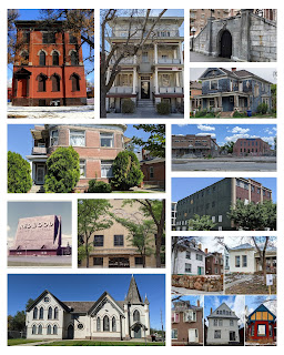
These are some of the historic buildings that were saved from demolition in 2021! Visit @demolishedsaltlakepodcast for some buildings that were lost this year.
 

Descriptions clockwise from the upper left corner:

1. Hyland Exchange, 847 S 800 E SLC. It will be converted to housing. But, 2 Victorian homes were demolished.

2. The Annex Apts, 150 E South Temple SLC. A project plans to rehab the Annex but it also demolished the Carlton Hotel next door.

3. Elks Block, 139 E South Temple SLC. Most buildings will be preserved, the Elks building will be renovated, the Elks tunnel entrance will be partially preserved.

4. House at 235 S 600 E SLC. The owner plans to add an addition to the back of the house and start repairs and rehab of the rest of the house.

5. Utah Pickle and Hide buildings at 737-741 S 400 W SLC. Some selective demolition has occurred but the main buildings are planned to be rehabbed.

6. Central Warehouse at 520 W 200 S SLC. The back half of the building has been demolished; the remaining front is to be integrated into a multi-use development.

7. These 5 houses on 200 East were subject to a rezone application which would result in their demolition. The rezone was not approved, and the houses are now being repaired.

8. 15th Ward Chapel at 915 W 100 S SLC was listed for sale which could have resulted in demolition; it was purchased by the Utah Arts Alliance and is now known as the Utah Art Castle.

9. Redwood Drive-In and Swap Meet at 3688 S Redwood WVC was proposed for demolition for a large housing project. Largely due to the backlash from the swap meet community the prospective owner decided to cancel the sale and development.

10. University of Utah’s Einar Nielsen Fieldhouse has undergone a seismic retrofit and will be converted to a theater.

11. Apt complex at 230 West 300 North SLC will be preserved while the area behind it will become additional multi-family housing.

It is important to note that only 2 of these projects had local historic preservation requirements for the property. All the others were only preserved because the owners desired it.

A big thanks to the owners, architects, engineers, and builders who all worked to keep some of Utah’s history standing.

31 October 2021

Happy Halloween

Ruth Delores Shulsen's award-winning Halloween
drawing, from Salt Lake Tribune 1937-10-31

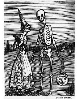
Happy Halloween! This spooky but cute drawing was done by 15-year-old Ruth Delores Shulsen and published on Halloween 1937 by the Salt Lake Tribune (Image 1).

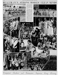
At the time Ruth (Image 2) was a participant of the Tribune-Telegram Youth Activity Club (YAC) which was an organization sponsored by the Salt Lake Tribune in the 1930s. The club offered daily activities for thousands of Utah’s children all taught by knowledgeable adults from the community

Typical activities of the club included swimming classes, tennis groups, arts and crafts, first aid classes, drum and bugle corps, marching band, movie outings, science and nature classes, woodworking, and a whole lot more. Both boys and girls were encouraged to attend any activity they wished (Image 3).

This drawing won 2nd place in the Youth Activities Halloween drawings contest and Ruth was awarded $2 (~$38 in today’s money). The 1st place drawing was done by Diana McQuarrie and featured a couple in Halloween costumes kissing on the dance floor (personally I like Ruth’s drawing better). Diana was awarded $3 for her drawing.

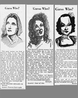
In their Youth Activities Club section of the newspaper, the Salt Lake Tribune also often published Ruth’s drawings of famous women along with a short biography in a section called “Guess Who?” (Image 4).

The Shulsen family lived on a 40-acre farm on the southeast corner of 9000 South and Redwood Road in West Jordan (now occupied by a strip mall, parking lot, and several fast-food restaurants). At the time, West Jordan was very rural and the closest neighbors were a quarter-mile away. Ruth graduated from Jordan High School in 1940 and one year later married the neighbor boy next door, Horace S. Young Jr.

Ruth was knowledgeable about literature and loved to write, draw, and paint with watercolors.

Sources: SL Trib 1937-10-03; SL Trib 1937-10-24; SL Trib 1936-06-28; FamilySearch documents

Ruth Delores Shulsen 17-years-old, from FamilySearch

Youth Activities Club, From Salt Lake Tribune 1936-06-28

Some of Ruth’s “Guess Who?” illustrations,
from SL Trib (L to R) 1938-06-05, 1938-03-06, 1938-01-23