28 September 2022

These trail markers tell the story of historic migrations and explorations in their own words

Trail marker at the summit of Dugway Pass, Dugway Mountain Range, Utah

In my last #WestDesertWednesday post I talked about the U.S. Army’s Capt. James H. Simpson’s 1859 expedition to map an overland route heading west from Salt Lake City and Camp Floyd, a decade before the joining of the railroads at Promontory Point in 1869.

This route was utilized by the Pony Express (mail stations began to be established in 1858 and were in operation 1860-1861), Overland Stagecoach (1860s-1890s or so), Lincoln Highway (1913+), and in some places U.S. Route 40 (1926+). It was a successful route because it avoided the mucky Great Salt Lake Desert (ahem… Donner Party) and utilized the many natural springs in the area.

Eventually, this route was abandoned in favor of what is now Interstate 80 across the Salt Flats…. The creation of that cut-off route is a complicated story in and of itself.

Nowadays, you can drive much of Simpson’s original route through Utah’s West Desert, and I plan on showcasing several interesting stops along the way.

These historic trail markers are found along the various historic trails. They provide a brief excerpt from written reports of the original explorations. These markers are established and managed by the Utah Chapter of the Oregon-California Trails Association (OCTA). https://www.utahcrossroadsocta.org

Here are a few that I saw along a recent weekend trip through Utah’s West Desert.


The 2 maps shown here are taken from BLM publications on the Pony Express in Utah.


21 September 2022

A Route for the Overland Stage, a FREE book to download

May 2, 1859, Capt. James H. Simpson departed from Camp Floyd (now a Utah State Park Museum in Fairfield, UT) and headed west “to explore the country between [Camp Floyd] and Carson River, at the east foot of the Sierra Nevada, for a new and direct route to California.”

Illustration from Simpson’s expedition, "Crossing the Great Salt Lake Desert from Simpson's Spring to Short Cut Pass, Granite Mountain in the Distance." Image from the National Archives.

This new overland trail would eventually become the general route of the Pony Express, Overland Mail and Stage, Pacific Telegraph line, the transcontinental Lincoln Highway, and Highway 50.

Photograph of a stagecoach that was used on the overland trail.
Image from Special Collections, J. Willard Marriott Library, link here.

Simpson was an Army Topographical Engineer, an elite group hand-picked from West Point. (The Topographical Engineer Corps merged with the Army Corps of Engineers in 1863, which the organization is known by today).

The 64 members of his expedition included an artist, geologist, wheelwright, blacksmith, teamsters, surveyors, 20 soldiers, 12 six-mule wagons, and scientific apparatus.

After Jesse G. Petersen retired in 1999 as Police Chief of Tooele, he set about exploring the various trails of the Great Basin. In 2003 he authored the Utah volume of The Lincoln Highway book series and in 2008 he authored A Route for the Overland Stage. The goal of both books was to identify the exact locations of the trails, not just the general location which is commonly identified.

In recent years, Utah State University Press has made his Overland Trail book available for FREE as a downloadable PDF. The book intermixes Simpson’s recordings along with Jesse Petersen’s field observations.

Cover of  "A Route for the Overland Stage" by Jesse Petersen

Excerpt from "A Route for the Overland Stage" by Jesse Petersen

Excerpt about Camp Floyd, from "A Route for the Overland Stage" by Jesse Petersen

Excerpt from "A Route for the Overland Stage" by Jesse Petersen.
(I added the green note).

One note of caution about the book, the coordinates published are in NAD27 and most GPS’s today default to WGS-84 or NAD83.

The link to the USU download site is here: https://digitalcommons.usu.edu/usupress_pubs/114/

Citation for the book:
Petersen, Jesse G., "A Route for the Overland Stage" (2008). All USU Press Publications. 114.
https://digitalcommons.usu.edu/usupress_pubs/114

Illustration of Bridal Veil Falls from Simpson’s expedition, titled "Beautiful Cascade, Timpanogos River Canyon." Image from the Utah Division of State History [color corrected by author]

19 September 2022

A Recap of the 2022 Sema Hadithi History Conference

What a weekend with the Sema Hadithi Foundation!

On Friday, we toured the Richmond Park area, a historically Black and multi-racial neighborhood in SLC, and talked about the lives of four remarkable women (Images 1-2).


Friday night was a remembrance celebration where I received an award for researching forgotten histories.

Some great food was provided by @papastewskitchen and entertainment with @pepper.rose.slc, @findafinley, @caribbean.nightingale. (Images 3-6)


And I learned about the cultural significance of red velvet cake (Image 7) and found that I really liked this Honey Lovin Hot Sauce from Papa Stew's Kitchen (Image 8).


Saturday was the history conference. I presented about H. H. Voss and Franklin Ave (now Edison Street). And I learned all about the importance of military bands and their relation to the 24th Infantry Buffalo Soldiers stationed at Fort Douglas, from @fiona_robinson.


A good, but busy, weekend.

07 September 2022

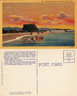
Vintage Postcards Showing Black Rock in the Great Salt Lake

More vintage postcards about the Great Salt Lake, these are specifically about Black Rock.

The first postcard is from the 1910s-1920s and the others are 1940s.

The second postcard is actually at Sunset Beach, which is just a smidge east of Black Rock. Sunset Beach is between Black Rock and the Great Salt Lake Marina.

And, as an FYI, the Great Salt Lake Marina is at Silver Sands Beach.

I didn’t realize until recently that we had named beaches


Vintage Postcards About the Great Salt Lake

“Greetings from the Great Salt Lake” is the topic of today’s #WestDesertWednesday

I like looking at old postcards to see how the landscape and people have changed. When looking at postcards about the Great Salt Lake there seems to have been quite a bit of human interaction with it in the past- both locals and tourists. Obviously, Salt Air was a hot spot but so was Black Rock (which I will post those images right after this one).

Now Black Rock is a lonely rock and is high and dry. The marina is unusable and all the boats have been pulled out. Those wood trestles of the Lucin Cutoff have been pulled out (and repurposed by a local).

And even the new Great Salt Air seems a lonely shadow of its past.

My guess is that most of these postcards are from the 1970s-1980s. The postcard showing the reading of newspapers in the lake is probably from the 1940s. And the new Great Saltair postcard appears to be from 1990s.


Source of images: personal collection and Ebay.