Obscure history and archaeology of the Salt Lake City area (plus some Utah West Desert) as researched by Rachel Quist. Follow me on Instagram @rachels_slc_history
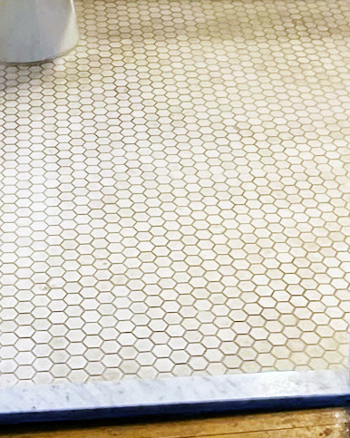
Check out these pics of an original bathroom in the Hillcrest Apartments, 173 E 100 South SLC.
The Hillcrest was built in 1916 by the Covey Investment Co.
The Covey Investment Co (the Covey brothers) built several apartment complexes around SLC. Their first project was the La France, which was built in 1905. It was the first collaboration among Covey Investment Co, architect David C. Dart, and builder Charles Andrew Vissing.
This group built about 20 apartment buildings in SLC, many of which survive today including the Kensington, Princeton & Boulevard, The Covey, and Hillcrest buildings.
Lots of people commented on my posts about the demolition of the La France that the same tile was used in other Covey buildings.
I was able to find a newspaper clip from 1916 that states Frank A Caffall did all the tile work for the various Covey properties.
The Caffall family is still in the tile business in the Salt Lake area.
This fun image of SLC and the University of Utah comes from the Jan 11, 1988, edition of The Daily Utah Chronicle.
A lot of these landmarks are still standing including Huntsman Center, Marriott Library, University Union, Kingsbury Hall, Park Building, and the Fieldhouse building.
Other locations like the golf course (now gone), the stadium (modified for the 2002 Olympics), Medical Center (now University Hospital which keeps growing), and University Student Housing (East and West University Village student housing, now undergoing demolition and rebuild) have undergone significant changes.
The prominent “twin towers” in this illustration are the Medical Plaza Towers student housing. That twin towers term certainly did not stand the test of time.
The second image is the full size showing the entire illustration.
US Air Mail arrow, north end of Skull Valley. Designation SALT LK AWY BN 59.
This large concrete arrow in Utah’s West Desert is part of the old Post Office Airmail system. These arrows are scattered all over the country but this one is my favorite because access is easy in that 1) it is on public land, and 2) it is right off Exit 77 of I-80.
Just a few years after the Wright Brothers' first flight, airplanes were used sporadically to carry the mail. During WWI, significant advancements were made by the US Army (no Air Force until after WWII) in airplanes and they had proven their utility.
So, in 1918 the Post Office asked the Army to create a system to fly mail on a regular basis for faster delivery. The Army developed and ran the airmail for the first 3 months using converted Army planes.
The Army then handed the system off to the Post Office to manage. Initially airmail only ran in the eastern states but slowly the rest of the US was included.
By Sept of 1920, airmail was flown across the country, from NYC to San Francisco, but only by day because night flying was difficult due to the inability to see the railroad tracks that they typically followed. So, a national system of night beacons atop concrete arrows showing the way was developed to guide the pilots.
As usual, Utah’s West Desert was a challenge and took until 1929 to complete the east-west transcontinental route. Each arrow pointed the direction to the next arrow on the route, typically 10-15 miles away.
Atop the tower was a rotating beacon with 2 directional spotlights showing the proper direction. Red lights were chosen over white lights as they could be seen from a farther distance. Green lights were used when there was an emergency landing strip nearby.
This was the system the airmail used for decades. Innovations in the technology that aided pilots were constantly developing. And eventually, the air beacons became unnecessary.
The Timpie airmail beacon was dismantled in May 1965 along with several others in Salt Lake and Tooele Counties.
This arrow was painted orange by a local boy scout troop, about 2017. Historically the arrow would have been yellow.
Arrow in May 2022
Here is how the arrow looked in 2016, before it was painted.
And here are various maps of the airmail routes:
United States Post Office Department map of air mail routes, 08/21/1928. (Source)
Clip of the 1924 airmail route, showing Salt Lake City to Timpie, via Grantsville. From US Army, Air Corps, US Army Corps of Engineers & Geological Survey, USTB. (1924) Aeronautical strip maps of the United States.
Ancient footprints are preserved in the Great Salt Lake Desert. An excavated footprint is in the foreground but you can also see unexcavated footprints (which appear like darker shadows in this image) in the background. July 2022.
Hill AFB recently announced a unique archaeological site in the GSL Desert on their South Bombing Range.
Named the Trackways Site, it consists of several tracks of human footprints likely dating to about 12,000 years ago.
Thousands of Paleo-age archaeological sites have been found in this area of the GSL Desert, including the famed Wishbone Site with a radiocarbon date on a fire hearth of 12,300 years ago. Although the finding of intact human footprints is surprising, it is in line with previous discoveries in the area.
The archaeologists are being cautiously optimistic about the authenticity of the find, citing more research is required.
I visited this site a short time before the official press release; I went in skeptical and left fairly convinced of its human antiquity. The stratigraphy is what ultimately convinced me.
Nowadays, that area of the GSL Desert is a wide-open alkali flat almost void of all flora and fauna, which means most people avoided it for most of the last 10,000 years.
The GSL Desert was once the bottom of Lake Bonneville in which fine silts were deposited on the lake floor. Then, during the waning years of Lake Bonneville, the area became a vast wetland fed by overflow water through the Old River Bed and springs, thus creating a vast wetland known as the Old River Bed (ORB) Delta.
The type of sediment deposited during each of these stages also changed from the fine silts of a deep lake to the sands and gravels transported by faster flowing streams.
These unexcavated footprints are inverted sand-filled prints. The sand erodes at a slower rate than the surrounding Lake Bonneville silt, These footprints are a part of a longer footprint trackway. July 2022.
The footprints themselves appear to have been formed when people walked in the shallow water of this ancient wetland. Their feet sunk through the sand into the underlayer of fine Bonneville silts, which were then filled in with the overlayer of sand after the foot was removed. Consequently, the footprints were preserved as sand-filled imprints, some of which are now exposed as inverted sand prints surrounded by alkali flats.
Here is the link to the original Hill AFB press release.
The Salt Lake Valley has Lake Bonneville shorelines on the west (Oquirrh) and east (Wasatch) sides of the valley. You just need to look at the mountainsides to see those etched horizontal lines (the Provo and the Bonneville being the easiest to spot).
But it is also fun to see where those shorelines are in areas where it is more difficult to spot them, like under the built environment of our cities.
This map shows how the cities of Salt Lake County are situated in relation to the shorelines.
Lake Bonneville was a Pleistocene-age lake (the last Ice Age). Similar to how the Great Salt Lake is today, the shorelines of ancient Lake Bonneville responded to changes in climate; the lake level increased when it was wetter/cooler and it lowered when it was warmer/drier.
Lake Bonneville was one of several closed-basin lake systems in the Great Basin during the last Ice Age; Lake Lahontan in Nevada being the largest but lots of little ones too. If you find yourself on a playa anywhere in the Great Basin, then you are at the bottom of an ancient lakebed.
The maps in my post show the geographic extent of Lake Bonneville overlayed on top of a modern map. I will detail the SLC area in my next post. The images are in order of highest elevation to lowest, but not in chronological order.
The Stansbury level is the oldest of the main shorelines. The final image shows the Great Salt Lake modern low (today).
Lake Bonneville was a cold freshwater lake. The highest mountain tops (Wasatch, Deep Creeks, etc) had large glaciers and the lake had its fair share of icebergs floating around, it was the Ice Age after all.
My interest in Lake Bonneville relates to the first people living in our area. It’s unclear exactly when people first inhabited the Bonneville Basin. Clearly, people did not live underwater but the shorelines certainly were utilized at some point.
Archaeological evidence shows that people were living and working along shorelines, at least around the Gilbert phase during the Pleistocene-Holocene transition.
A human-made fire hearth documented at the Wishbone archaeological site in the Great Salt Lake Desert shows people were in this area at least by 12,300 years ago. It seems that at least parts of the lake at this time supported freshwater fish and there is direct evidence of Mammoths and waterfowl present, making it an attractive place for ancient people.


.jpg)
.jpg)


